The east side of Nusa Penida does not have a T-Rex shaped cliff or a natural archway you can photograph from the road. What it has is something harder to put into a caption: a quality of experience that most visitors to the island never find because they spend their entire day on the western circuit and leave on the afternoon ferry without knowing the east exists in any meaningful way. Diamond Beach and Atuh Beach have since changed that, and the photographs that have emerged from the eastern coastline have started drawing a different kind of traveler. One who is willing to go further, climb more stairs, and drive a road that earns its reputation.
The problem is that most content about the east Nusa Penida tour is written to the same depth as a photograph caption. Diamond Beach looks like this. Atuh Beach is nearby. The stairs are steep. That is the entirety of most guides, and it leaves travelers arriving on the island with the same questions they had before reading: how many stairs, how long does the descent take, does the road to the east side actually require a skilled driver, is the beach worth what it costs in physical effort, and is the east route better or worse than what is on the west?
This guide is the honest, specific version of that information. Every major site on the east circuit is assessed for what it actually delivers, what the physical reality is, what time of day produces the best experience, and what type of traveler it suits. The road gets a frank assessment. The east vs west comparison is made directly. The day timeline is realistic rather than aspirational. By the time you finish reading, the east Nusa Penida tour will feel like a clear decision rather than an uncertain one.
Why the East Route Attracts a Different Kind of Traveler
The east Nusa Penida route is not a standard substitute for the west. It is a genuinely different experience with a different pace, a different physical character, and a different reward. Understanding this distinction is what separates travelers who arrive ready for it from those who arrive expecting something similar to Kelingking and leave confused by the comparison.
The Character of the East Side and How It Differs From the West
The west coast of Nusa Penida is defined by dramatic cliffs and famous formations that can be photographed from clifftop viewpoints without significant physical effort. The east coast is defined by beaches that require you to earn them. Diamond Beach sits at the bottom of approximately 300 stairs. Atuh Beach involves its own descent. Rumah Pohon is reached by a walk through fields above the cliff. The east route asks more of the body at each stop, and in exchange it delivers something the west cannot: beaches and views that feel genuinely personal because the access filters out everyone who was not willing to make the effort.
The east coast also has more silence. Fewer tour groups operate on the east route because the road is more demanding and the drive from the port is longer. At Diamond Beach in the early morning, it is entirely possible to be on a stretch of extraordinary white sand with only a handful of other people, looking up at limestone formations and turquoise water that rival anything in Southeast Asia. That experience is rare on the west route where crowds build quickly. On the east, it is the standard condition for early arrivals.
Who the East Route Suits and Who It Does Not
The east route is not for everyone, and pretending otherwise would be a disservice to travelers making real planning decisions.
The east route is well-suited for:
- Travelers who have already done the west route and want to experience a genuinely different side of the island on a second visit
- Beach lovers and swimmers whose primary interest is spending time at extraordinary beaches rather than viewpoints
- Photography-oriented travelers who want dramatic coastline images without the crowd competition of the famous west sites
- Physically confident travelers who are comfortable descending and ascending several hundred stairs and who have appropriate footwear for the terrain
- Couples and small groups seeking a quieter, more personal experience that the east route’s lower visitor density consistently delivers
The east route is less suited for:
- Travelers with limited time who want to cover the most famous Nusa Penida sites in a single day, for whom the west route remains the better choice
- Anyone with knee problems, limited mobility, or significant difficulty with stairs, as Diamond Beach’s access stairs are genuine and unavoidable
- Groups that include members whose fitness or mobility makes the stair descent at Diamond Beach inadvisable
The east route is not lesser than the west. It is different in ways that specifically reward the travelers it suits, and those travelers tend to describe it as the best part of their Nusa Penida experience.
Diamond Beach and the Descent That Makes It Worth the Effort
Diamond Beach is the east route’s most famous site, and it earns that status for the right reasons. The beach at the base of the limestone cliff is a crescent of white sand with turquoise water and dramatic rock formations rising from the sea at the eastern end. The photographs are accurate. The experience of being there is extraordinary. The question is what it takes to get from the clifftop parking area to the sand below, and this is where most guides fall short of useful.
What the Beach Looks Like When You Actually Reach It
When you come around the final turn of the staircase and step onto the sand at Diamond Beach, the visual shift is immediate and significant. The rock formation at the eastern end of the beach, a jagged limestone outcrop that rises from the water like a series of broken columns, frames the beach in a way that feels constructed rather than natural. The water in the channel between the rock formation and the beach is a specific shade of blue-green that photographs accurately for once. The sand is fine and white, the beach is relatively narrow, and the scale of the limestone cliff behind and above is not fully apparent until you turn around and look up at where you came from.
The water is swimmable on calm days, though currents can be stronger than the protected appearance of the beach suggests. Check with your guide about conditions before entering. The beach has a small warung at the base of the stairs where cold drinks and snacks are available, which matters more than it sounds after the descent.
The Stairs, the Climb Back Up, and What to Prepare For
The staircase at Diamond Beach descends approximately 300 steps from the clifftop to the beach. The steps are mostly concrete and reasonably maintained, but they are steep and the sections nearest the beach become irregular where the path meets the natural rock. The descent takes most people between fifteen and twenty-five minutes at a comfortable pace. The ascent back up takes twenty-five to forty minutes depending on fitness and the temperature at the time of day.
This last point matters more than most guides acknowledge. Climbing 300 steps at 11am in Bali’s tropical heat is a genuinely demanding physical experience. Climbing the same stairs at 8am in cooler morning air is considerably more manageable. The time of day at which you attempt the Diamond Beach descent directly affects how physically taxing the return trip feels, and planning to arrive early specifically to complete the descent before the midday heat is one of the most useful practical decisions you can make on the east route.
The descent also requires appropriate footwear. The stairs are steep enough that smooth-soled sandals or flip-flops significantly increase the risk of slipping, particularly in the lower section where moisture from sea spray can make the surface less predictable. Closed-toe shoes with grip or trail sandals with ankle support are the minimum sensible standard.
The Best Time of Day to Be at Diamond Beach
The optimal window for Diamond Beach is between 7:30am and 10:00am. In the early morning, the light comes from the east and falls directly on the beach and the rock formations, producing the warm directional light that makes the colors of the water and sand most vivid. By late morning the sun is overhead and the light flattens. By midday the heat on the descent and ascent becomes a significant physical factor.
Arriving at Diamond Beach before 9am also positions you ahead of the tour groups that depart on later ferry crossings. The east route has fewer tour groups than the west, but those that do operate on this circuit tend to arrive at Diamond Beach between 9:30 and 11:00am. Being there before they arrive means having the beach with a fraction of the visitor numbers, which changes the experience in a way that is difficult to overstate.
Atuh Beach and What It Offers Beyond the Famous Neighbour
Atuh Beach sits a short drive from Diamond Beach and is almost always included in east route itineraries as a natural second beach stop. It does not have Diamond Beach’s staircase drama or its fame, which is precisely what makes it worth including. The two beaches offer genuinely different experiences, and understanding what Atuh specifically delivers helps travelers set realistic expectations and appreciate it for what it is rather than measuring it against Diamond.
How Atuh Differs From Diamond Beach in Atmosphere and Access
Atuh Beach is wider and more open than Diamond Beach. The rock formations in the water off Atuh’s coastline are different in character, lower and more spread across the water’s surface rather than rising dramatically at one end. The beach is flanked by gentler hillsides rather than dramatic limestone cliffs, which gives it a more sheltered and less vertigo-inducing atmosphere than Diamond.
The access at Atuh involves stairs, but fewer of them than Diamond Beach and with a gentler gradient in the final section. Most visitors reach the beach in ten to fifteen minutes from the parking area. There is a small selection of beach warungs at Atuh that are slightly better established than the single warung at Diamond, which makes it the more comfortable spot for a longer rest or lunch stop between beach visits.
Swimming, Scenery, and Why Some Travelers Prefer It
Atuh Beach is frequently preferred over Diamond Beach by travelers whose priority is swimming rather than photography. The water entry at Atuh is more gradual, the beach is wider and less crowded, and the natural rock pools at low tide in the shallower areas provide a calmer alternative to the open ocean for those who want to be in the water without strong currents. The views from the water looking back toward the beach and hillside are genuinely beautiful, if less dramatic than Diamond’s cliff backdrop.
Atuh also has a quality of calm that Diamond Beach, which sees more visitors and has a more photographically driven atmosphere, does not always maintain. Travelers who sit at Atuh for an hour, swim, eat, and watch the water tend to describe it as the moment the east route stopped feeling like a tour and started feeling like an actual beach day. That quality has genuine value, and providers who rush through Atuh on the way back to the port miss the point of including it.
Rumah Pohon Treehouse and the Viewpoint That Justifies the Drive
Rumah Pohon is the east route site that most visitors know the least about before arriving and remember most clearly afterward. The name translates as treehouse, and the structure at the clifftop above Diamond Beach is exactly that: a wooden treehouse platform built into the cliff edge that offers an unobstructed panoramic view across the eastern coastline of Nusa Penida. It is not a polished tourist attraction with a ticket booth and a gift shop. It is a simple structure in an extraordinary location, and the view from it at the right time of day is among the most memorable available anywhere in Bali.
What the Panoramic View Actually Looks Like From the Top
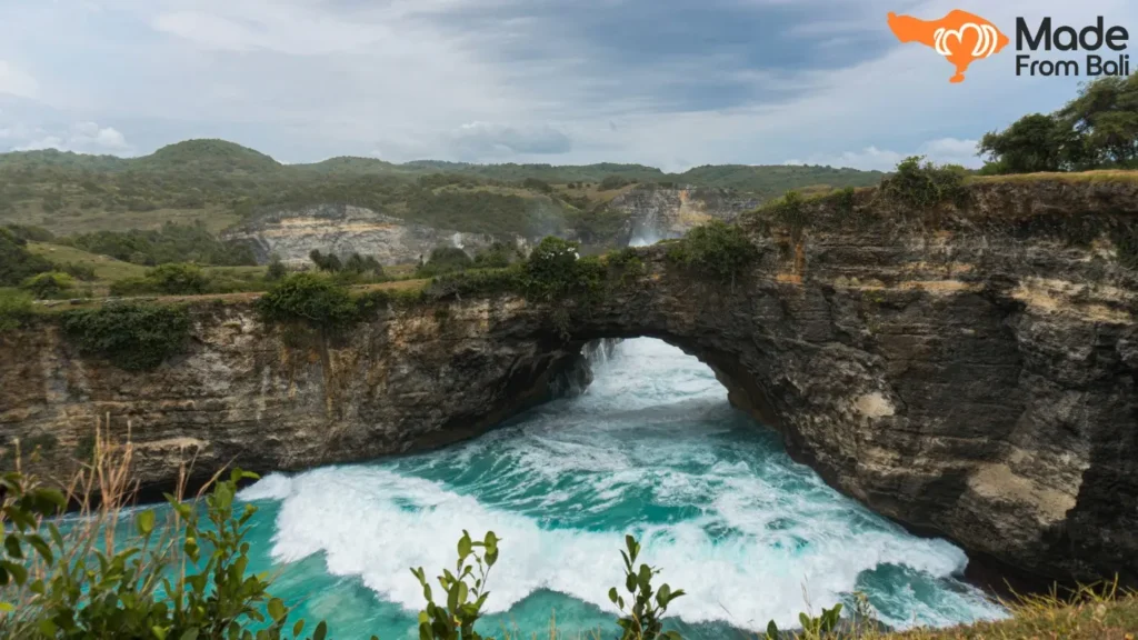
From the Rumah Pohon platform, the eastern coastline of Nusa Penida spreads in both directions below. Diamond Beach is visible directly below to the south, a white crescent against turquoise water. Atuh Beach is visible further along the coast to the north. The limestone formations along the cliff edge extend both ways, and the sea fills the horizon in the east with nothing between you and the open Indian Ocean. On clear days, the visibility extends far enough that the distinction between the deep blue of the open water and the lighter turquoise of the shallower areas near the cliff base is sharp and dramatic.
The platform itself accommodates a small number of people comfortably. When it is not crowded, which is most of the time outside of peak season, the experience of standing on the structure with the view in front and the wind off the ocean is genuinely immersive. There is no protective railing in the traditional sense, and the exposed position is part of what makes the experience feel so immediate and real. Travelers who are not comfortable with heights should assess their own response to the platform rather than assume it will be manageable.
Sunrise Timing at Rumah Pohon and Why It Changes Everything
Rumah Pohon faces east, which means it is one of the few sites in Bali’s island group with a direct sunrise orientation over open ocean. This fact transforms the site’s value for travelers who are willing to arrive before dawn. At sunrise, the light appears directly in front of the platform and illuminates the coastline below in a quality of golden and pink light that lasts approximately fifteen minutes before the sun rises fully and the directional quality disappears.
For travelers who have done the Batur sunrise trek and want a sunrise experience without the physical climb, or who simply want a more solitary, less-crowded alternative to the volcano, Rumah Pohon at sunrise is a genuinely remarkable option. It requires either staying overnight on Nusa Penida, which makes a two-day east route format the natural pairing, or taking an extraordinarily early ferry from Sanur, which limits this option to travelers with extremely early departure flexibility.
Even outside of sunrise, the early morning hours at Rumah Pohon, between 7:00 and 9:00am, produce dramatically better light than midday visits. The coastal view in flat overhead light loses the depth and color that directional morning light provides. Arriving at Rumah Pohon first thing on an east route day, before driving down to Diamond Beach, is the sequence that makes the most of the morning light at both sites.
Other East Route Sites Worth Including in Your Day
The east circuit contains more than Diamond Beach, Atuh Beach, and Rumah Pohon, though these three form its core. Depending on the length of the day, the interests of the group, and how much time is spent at the main sites, two additional stops can meaningfully enrich the east route experience without overloading the itinerary.
Teletubbies Hill and the Rolling Green Landscape
Teletubbies Hill sits in the interior of the island, between the port and the east coast, and it offers something that no clifftop viewpoint or beach on the island can: a gentle, rolling green landscape of open grassland that looks, with the right imagination, like the landscape of the children’s television series that gave it its local nickname. The hills are low, the grass is maintained by grazing animals, and the visual character of the place is entirely unlike the dramatic limestone cliff scenery that defines the rest of Nusa Penida.
Teletubbies Hill is not a major destination in itself. It works best as a ten to fifteen minute stop on the drive from the port to the east coast, where it serves as an orientation moment and a pleasant photographic pause before the coastline takes over. Travelers who skip it miss nothing essential. Those who stop are usually glad they did, particularly because the interior landscape of Nusa Penida is so different from anything visible from the coastline that it provides useful geographic context for the island as a whole.
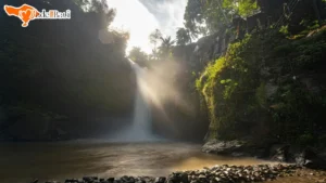
Seganing Waterfall and Whether the Walk Is Worth It
Seganing Waterfall sits on the eastern coast and requires a walk of approximately twenty to thirty minutes from the access point to reach. The walk involves descent on a path that is steep in sections and passes through agricultural land before reaching the cliff and waterfall area. The waterfall itself drops into the sea rather than into a pool, which makes it a visual experience rather than a swimming opportunity.
The honest assessment of Seganing is that it suits travelers who have time to spare and genuinely enjoy walking through natural terrain for its own sake, rather than those who are primarily site-focused. On a full east route day that already includes Diamond Beach, Atuh Beach, and Rumah Pohon, adding Seganing extends the physical demand of the day significantly and may feel like too much. On a two-day visit to the island, or for travelers who are specifically interested in coastal waterfalls, it adds a genuine dimension to the east circuit that the main sites do not replicate.
East Route vs West Route on Nusa Penida
This is the planning question that most east route searches are ultimately trying to answer, and it deserves a direct and honest response rather than a diplomatic “both are great in different ways” non-answer. The two routes serve different purposes and suit different travelers, and the right choice depends on specific factors that can be assessed before you book.
An Honest Comparison of What Each Route Delivers
The following comparison is built on what each route actually provides rather than what their marketing suggests.
| Factor | West Route | East Route |
|---|---|---|
| Most famous site | Kelingking Beach viewpoint | Diamond Beach descent |
| Physical demand | Moderate (descent optional) | Higher (stairs required at main beaches) |
| Crowd level | Higher, particularly at Kelingking | Lower across all sites |
| Beach access | Crystal Bay (accessible) | Diamond and Atuh (stairs required) |
| Viewpoint variety | Multiple dramatic clifftop views | Rumah Pohon panoramic, less variety |
| Road difficulty | Moderate | The island’s most challenging road |
| Best for | First-time visitors, viewpoint photography, snorkeling | Repeat visitors, beach swimmers, quieter experience seekers |
| Sunrise opportunity | Limited from the road | Rumah Pohon faces east over open ocean |
| Recommended trip length | One day is sufficient | Two days allows Rumah Pohon sunrise |
The west route is the right choice for first-time visitors who want the most famous Nusa Penida experience and who have limited time. The east route is the right choice for travelers who specifically want extraordinary beaches without west route crowds, who have already done the west, or who are drawn by Diamond Beach and Atuh Beach specifically.
Can You Do Both Routes in One Day
Technically, yes. Practically, for most travelers, no, and the reason is worth explaining clearly. A combined east and west route day requires an extremely early ferry from Sanur, a private guide who knows both routes and can manage the timing, and a willingness to spend the day primarily in a vehicle rather than at the sites. The drive from the west coast sites to the east coast sites crosses the island and takes forty-five minutes to over an hour on roads that are not fast.
Travelers who attempt both routes in a single day consistently report feeling rushed at every site and arriving at the last few stops without the energy to enjoy them. The sites on both routes reward time and attention. Diamond Beach deserves at least forty-five minutes on the beach after the descent. Rumah Pohon is best enjoyed slowly. Kelingking deserves a proper morning window.
The honest recommendation is this: if you have one day on Nusa Penida, choose one route and do it well. If you have flexibility for two days on the island, use day one for the west and day two for the east, starting with Rumah Pohon at sunrise. That combination produces the fullest version of what Nusa Penida offers.
The East Coast Road and Why Transport Choice Matters Here
The east coast road is the most frequently underestimated variable in east Nusa Penida planning, and addressing it honestly is more useful than the standard “roads can be bumpy” warning that appears in most travel guides. The road to the east coast is genuinely demanding in ways that make transport choice consequential rather than merely a matter of preference.
What the Drive Actually Feels Like on the East Route
The road from Toya Pakeh port to the east coast sites involves an initial section through the island’s interior that is reasonable by Nusa Penida standards, followed by a descent toward the eastern coastline on a road that narrows, steepens, and in places becomes genuinely technical for the driver. The surface alternates between paved sections and sections of rough or broken asphalt. The gradient near the eastern cliff areas is steep enough that engine braking becomes audible even in well-maintained vehicles.
The drive takes approximately forty-five minutes to an hour from the port to Diamond Beach in a private vehicle driven by someone who knows the road. It takes longer in unfamiliar hands. The landscape along the east coast road is striking, passing through farming areas, scrubland, and occasional glimpses of the eastern sea, and the sense of remoteness that builds as you move further from the port is part of what gives the east route its character. But the road is not a sightseeing backdrop. It requires an attentive driver throughout.
Private Driver vs Scooter on This Specific Road
The scooter rental question on Nusa Penida in general is a nuanced one. On the east coast road specifically, it is less nuanced. The combination of gradient, surface variability, and road narrowness on the east route makes scooter riding a significantly higher risk activity here than on the more developed western access roads. Travelers who are experienced off-road riders on similar terrain may manage it safely. Travelers who rent scooters primarily for flat or well-paved roads and have not ridden on steep, variable-surface roads before are taking a risk that the experience does not justify.
A private driver with a vehicle appropriate for the east coast road, which means a properly maintained four-wheel vehicle rather than a compact car, handles the road as a matter of course. The cost difference between scooter rental and a private driver for the island portion of the day is smaller than most travelers assume, particularly when accounting for two riders versus one vehicle. For the east route specifically, the private driver recommendation is not a comfort preference. It is a practical safety assessment based on what the road actually involves.
Your Complete East Nusa Penida Day Timeline
The east route runs on different logistics from the west. The drive times are longer, the physical demand at each site is higher, and the number of sites that can be visited without rushing is smaller. The following timeline is built around a realistic one-day east route from south Bali, arriving on the first available ferry.
From the Ferry to the First Site
- 5:30 to 6:15am: Pickup from accommodation in south Bali, drive to Sanur Harbor. Time depends on accommodation location.
- 7:00am: Fast boat departs Sanur Harbor for Nusa Penida. The crossing takes approximately 35 to 45 minutes.
- 7:45am: Arrive at Toya Pakeh port. Transfer to the island vehicle and brief orientation with the guide.
- 8:30 to 8:45am: Arrive at Rumah Pohon viewpoint. This is the ideal first stop on the east route because the morning light falls directly on the eastern coastline and the experience of the viewpoint before the day heats up is significantly better than in the afternoon.
Moving Through the East Circuit Realistically
| Time | Site | Notes |
|---|---|---|
| 8:45 to 9:30am | Rumah Pohon Treehouse viewpoint | 45 minutes allows proper time to absorb the view |
| 9:30 to 10:00am | Drive down to Diamond Beach area | Short drive from Rumah Pohon to the Diamond Beach stairs |
| 10:00 to 11:30am | Diamond Beach | 30 minutes descent, 30 to 45 minutes on the beach, 30 to 40 minutes ascent |
| 11:30am to 12:15pm | Drive to Atuh Beach and lunch stop | Lunch at a local warung near Atuh |
| 12:15 to 1:15pm | Atuh Beach | Swimming and beach time |
| 1:15 to 1:45pm | Optional: Teletubbies Hill on the drive back | 15 to 20 minute stop |
| 2:00pm | Begin drive back toward Toya Pakeh port | Allow at least 45 to 60 minutes for the drive |
| 3:00pm | Arrive at port, prepare for return ferry | |
| 3:30pm | Return fast boat to Sanur | |
| 4:30 to 5:30pm | Arrive back at south Bali accommodation | Depending on location and traffic |
This timeline is tight and leaves minimal buffer. Adding Seganing Waterfall requires either skipping Teletubbies Hill and trimming time at one beach, or accepting a later return ferry if one is available.
The Return Journey and Ferry Timing
The last reliable fast boat from Toya Pakeh to Sanur departs between 4:00 and 5:00pm depending on the operator. Building a buffer of at least thirty minutes before the intended departure is standard planning discipline. The east route’s longer drive times make this buffer more important than on the west route, where the port is closer to the final sites.
Afternoon seas between Nusa Penida and Bali are typically rougher than morning crossings due to the development of trade winds across the Badung Strait. If you experienced any motion discomfort on the morning crossing, take preventive medication before boarding for the return. The afternoon crossing is frequently bumpier and the difference matters for travelers with any sensitivity.
What to Bring and What the East Route Specifically Requires
The east Nusa Penida route has a specific preparation profile that differs from both the west route and a standard Bali day tour. The combination of stair descents, sun exposure on open beaches, a demanding road, and the island’s cash economy means that preparation the evening before directly affects the quality of the experience.
Footwear, Sun, and the Stair Descent Preparation
Footwear is the single most important gear decision for the east route. The Diamond Beach stairs require closed-toe shoes with grip or trail sandals with ankle support. Smooth-soled sandals and flip-flops are inadequate for the descent and create a real risk of slipping on the steeper sections near the base. If you do not have appropriate footwear and are based in south Bali, outdoor gear rental shops in the Kuta and Seminyak areas stock trail runners and hiking sandals at reasonable daily rates. This is worth arranging before the tour day rather than attempting the descent in poor footwear.
Sun exposure on the east route is intense and sustained. The Rumah Pohon viewpoint, the descent and beach time at Diamond Beach, and the open beach at Atuh are all fully exposed. The combination of direct tropical sun and sea reflection significantly increases effective UV exposure. Apply sunscreen before leaving accommodation, carry it for reapplication at each beach stop, and bring a hat and light long sleeves if sun sensitivity is a concern. The east route’s beaches are beautiful precisely because they are open and undeveloped, which means shade is minimal.
Cash, Timing, and the Mistakes First-Timers Consistently Make
Cash is the operating currency across the entire east route. There are no ATMs in the east coast area, and relying on finding one after arriving at the port is unreliable at best. Withdraw IDR from a Sanur or south Bali ATM before the tour day and carry enough for entry fees, lunch, beach warung drinks, and a guide tip.
Realistic cash requirements for the east route day:
- Entry fees at each site: approximately 10,000 to 20,000 IDR per site
- Lunch at a local warung: 40,000 to 80,000 IDR per person
- Beach drinks and snacks: 20,000 to 50,000 IDR per person
- Guide tip: 50,000 to 100,000 IDR if appropriate
The mistakes that east route first-timers consistently make are specific and preventable:
- Arriving at Diamond Beach after 10am: The descent in midday heat is significantly harder than in the morning, and the beach starts receiving more visitors after this time.
- Wearing inappropriate footwear for the descent: The stairs are not a casual walk and smooth-soled shoes create genuine risk.
- Not budgeting time for the ascent back up: The climb back from Diamond Beach always takes longer than the descent, and travelers who plan to be at the base for thirty minutes and then return quickly consistently find themselves running late.
- Attempting both east and west routes in a single day without understanding the time cost: The experience at each site suffers significantly when the day is built to cover too many stops.
- Bringing no cash from Bali: The east coast area has no ATMs, and the warung at Diamond Beach does not operate on credit cards.
Experiencing the East Route as It Was Meant to Be Experienced
The east Nusa Penida tour is not the logical choice for every traveler who arrives on the island. It is the right choice for a specific kind of traveler: one who is willing to make the physical effort, comfortable with a demanding road, and drawn by the quality of experience that the east route’s relative quietness and extraordinary beaches consistently deliver.
For those travelers, the east route regularly produces the most vivid memories of the entire Bali trip. Diamond Beach after the descent, with the limestone formations rising from the turquoise water and almost nobody else on the sand. Atuh Beach in the late morning with cold drinks from the warung and a swim in water that is calmer and clearer than most people expect. Rumah Pohon at first light with the eastern sea stretching to the horizon and the coastal cliffs lit from directly in front. These are experiences that require choosing the east route specifically and going with the preparation and the time that the route deserves.
Made From Bali’s east Nusa Penida tours are built with this understanding at their core. The ferry timing, the island transport choice, the site sequence logic, and the guide knowledge of Diamond Beach conditions and Rumah Pohon sunrise timing are all managed with the intention of giving the east route its best possible version rather than a rushed circuit designed to tick boxes. Choose the east route because you want what it specifically offers, prepare appropriately, and go with a provider who knows the difference between the road to Diamond Beach and every other road on the island.