Nusa Penida looks straightforward on paper. Take a fast boat from Sanur, see Kelingking Beach, visit Broken Beach and Angel Billabong, get back on the ferry. Plenty of travelers arrive with exactly this plan and discover, somewhere between the second unpaved road and the third missed turn, that the island requires considerably more preparation than a list of famous viewpoints. The photographs that draw people here are real. The effort required to reach them is also real, and it is consistently underestimated.
The gap between expectation and experience on Nusa Penida is where most disappointments live. Travelers who did not know about the road conditions show up in sandals and find themselves on rocky tracks in a scooter they are not confident riding. Couples who planned to cover both the east and west routes in a single day discover that the island’s geography makes that genuinely difficult without sacrificing depth at every stop. Families who did not research Kelingking Beach’s descent arrive at the viewpoint, look at the steep path below, and turn around without the experience they came for.
None of this needs to happen. With the right planning, Nusa Penida delivers some of the most visually extraordinary scenery in all of Bali, experiences that feel genuinely remote despite the boat ride, and a character unlike anything on the mainland. This guide covers everything: the route logic, the honest site assessments, the transport reality, the marine experiences, and the practical details that make the difference between a frustrating day and an exceptional one.
What Makes Nusa Penida Different From the Rest of Bali
Nusa Penida is not an extension of Bali. It is a different island with a different landscape, a different infrastructure, and a different pace that requires a different approach to planning. Travelers who treat it like a Bali day tour, arriving with a loose itinerary and assuming things will fall into place, consistently have a harder time than those who understand what the island actually involves before they arrive.
The Island’s Character and Why It Requires Different Planning
Nusa Penida sits roughly 20 kilometers southeast of Bali across the Badung Strait. It is larger than most visitors expect, covering approximately 202 square kilometers of dramatic limestone cliffs, rugged coastline, and agricultural plateau. The island was historically isolated from the tourist development that transformed Bali, and while that isolation has been breaking down rapidly since around 2016, it has left Nusa Penida with a landscape and infrastructure that rewards preparation rather than spontaneity.
The sites that made Nusa Penida famous are genuinely spectacular. Kelingking Beach, with its T-Rex shaped cliff formation and turquoise cove below, is one of the most photographed viewpoints in Southeast Asia. Diamond Beach, with its white sand accessible by steep stairs from the clifftop, is the kind of place that makes travelers question why they had not heard of it years earlier. The manta ray snorkeling at Manta Point delivers close encounters that most divers wait years to experience elsewhere.
What Nusa Penida does not have, at least not reliably, is the smooth infrastructure that Bali visitors are accustomed to. Road quality varies significantly across the island. Not all roads are paved, and those that are can be narrow, steep, and genuinely challenging to navigate without prior experience. Cash is the dominant currency across the island’s vendors, warung, and entry points. The ferry schedule dictates your day in ways that a private driver in Bali does not.
What the Roads Are Actually Like and Why That Matters
The road situation on Nusa Penida is the single most consistent surprise for first-time visitors, and addressing it honestly is more useful than glossing over it. The main road connecting the port of Toya Pakeh to the western sites has improved significantly in recent years and is generally paved and manageable. The roads leading to specific viewpoints and beaches, particularly on the west route toward Kelingking and on the east coast toward Diamond and Atuh Beach, involve steep descents, tight turns, and sections of unpaved or broken asphalt that require a competent driver.
This matters for two reasons. First, it affects the scooter rental question, which many budget travelers default to without fully accounting for the skill level the roads demand. Second, it affects timing. Roads that look close on a map take significantly longer to cover than the distances suggest, and building unrealistic time expectations into an itinerary is how people end up rushing through sites that deserve more time.
A private driver with an appropriate vehicle is the safest and most practical transport choice for the majority of international visitors, particularly those unfamiliar with riding on steep unpaved roads. This is not a luxury recommendation. It is a practical one, and the cost difference between renting a scooter and hiring a local driver on the island is less dramatic than most travelers assume.
Choosing Between the West Route and the East Route
The most important planning decision on Nusa Penida is not which tour operator to use or how much to spend. It is which route to prioritize, because covering both the east and west in a single day requires either very early starts, rushed time at each stop, or both. Understanding what each route offers and who each one suits makes this decision considerably cleaner.
What the West Route Covers and Who It Suits Best
The west route is where the island’s most iconic imagery lives. Kelingking Beach, Broken Beach, Angel Billabong, and Crystal Bay all sit in the western portion of the island within a logical driving circuit from the main port. This is the route that most one-day visitors take, and it earns that popularity for legitimate reasons: the cliff scenery is dramatic, the ocean colors are extraordinary, and the combination of sites delivers a visually varied day that covers both geological formations and marine access.
The west route suits travelers who are primarily driven by the famous viewpoints and want the Nusa Penida highlights experience in a single well-structured day. It also suits travelers who want to include snorkeling, since Crystal Bay is easily incorporated into the west circuit and Manta Point is accessible from the same general area. Families who need a manageable pacing structure will find the west route more practical, with clearer stopping points and shorter distances between sites.
The honest note about the west route is that it is the busiest part of the island. Kelingking Beach in particular draws significant numbers of visitors, especially between 9am and 11am when multiple tour groups tend to overlap. Arriving early makes a genuine difference to the atmosphere.
What the East Route Covers and Who It Suits Best
The east side of Nusa Penida is a different experience entirely. Diamond Beach and Atuh Beach are among the most beautiful stretches of coastline in Indonesia, and the Rumah Pohon treehouse viewpoint offers a panoramic perspective of the eastern coastline that rivals anything on the west. The east route is quieter, the roads are more dramatic, and the sites feel more like genuine discoveries than highlights on a well-worn circuit.
The east route suits travelers who have been to Nusa Penida before and want to go beyond the famous sites, those who are specifically drawn to beach access and want to spend real time at the water, and couples or small groups seeking a less crowded experience with more time at each stop. It also suits anyone who has already seen Kelingking Beach in photographs enough times to feel that the east coast’s relative obscurity is the more compelling draw.
The practical consideration is driving time. The road to Diamond and Atuh Beach involves the island’s most challenging section of route, and the descent to beach level at both sites requires a walk down steep stairs. The east route rewards travelers who move slowly rather than those who want to maximize the number of sites checked off.
One Day or Two Days on Nusa Penida
This is a decision that more travelers should make deliberately rather than defaulting to a one-day visit out of habit or itinerary convenience.
| Factor | One Day | Two Days |
|---|---|---|
| Route coverage | One route well, or both rushed | Both routes at a genuine pace |
| Depth at each site | Limited, especially if covering both | Sufficient time to explore properly |
| Cost | Lower, ferry and accommodation savings | Higher but significantly richer experience |
| Physical demand | Concentrated, tiring if both routes attempted | Spread across two days, more sustainable |
| Marine experiences | Possible but time-pressured | Comfortably included without sacrifice |
| Crowds | Peak hours unavoidable on one day | Early morning advantage on day two |
The one-day west route tour is the right choice for travelers with a tight Bali itinerary who want the island’s highlights without the overnight commitment. Two days is the right choice for anyone who wants to experience Nusa Penida fully rather than efficiently. Both are valid. The mistake is attempting both routes in a single day without accepting that the quality of each stop will suffer.
The West Route Sites and What Each One Actually Delivers
The west route is where most Nusa Penida itineraries begin and end, and for good reason. The concentration of visually extraordinary sites in a relatively compact geographic area makes it the most logical circuit for a one-day visit. Knowing what each site actually involves before you arrive removes the most common sources of surprise and disappointment.
Kelingking Beach and the Reality of the Descent
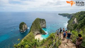
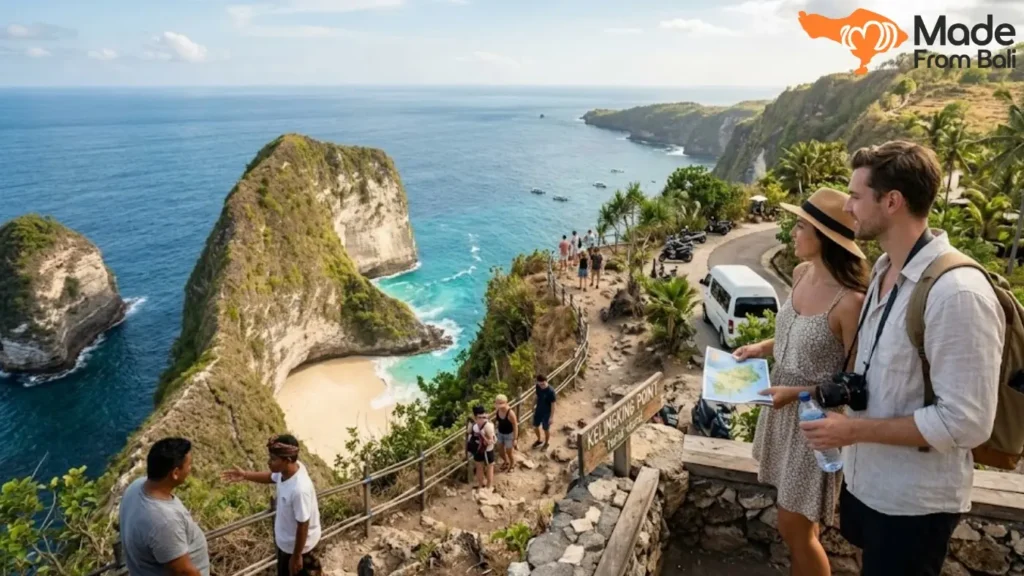
Kelingking Beach is the image most people see before deciding to visit Nusa Penida. The viewpoint, which looks down at the T-Rex cliff formation with a crescent of white sand and turquoise water below, is as dramatic in person as it appears in photographs. Most visitors stop here, take photographs from the clifftop, and leave. What the photographs do not communicate is that there is a beach down there, and that reaching it is possible.
The descent to Kelingking Beach is steep, takes approximately 30 to 45 minutes each way, and involves sections where you are moving down loose rocky path with significant drop-offs on one side. This is not a casual walk. It requires reasonable fitness, appropriate footwear with grip, and a willingness to work hard for the reward at the bottom. The beach itself is uncrowded, the water is extraordinary, and the view back up at the cliff from sea level is entirely different from what you see at the top.
For travelers who cannot or do not want to make the descent, the viewpoint itself is still genuinely worth visiting. For those who can manage it, the descent is one of the most rewarding physical decisions available on the island. The honest guidance is to wear proper shoes, start the descent before 8am if possible to avoid the midday heat, and budget at least two hours for the round trip including time at the beach.
Broken Beach and Angel Billabong
These two sites sit next to each other in the northwest of the island and are almost always visited together, which makes logistical sense since they share a parking area and can be explored within an hour as a combined stop.
Broken Beach, known locally as Pasih Uug, is a naturally formed archway in the limestone cliff that allows ocean water to circulate into a protected lagoon. The viewpoint is at clifftop level, the arch is clearly visible below, and the color of the water inside the formation is a specific shade of blue-green that is difficult to photograph accurately because it looks almost artificially saturated in real life. There is no access to the water here. The site is purely visual, but the visual is extraordinary.
Angel Billabong is a few minutes walk away and offers a very different experience. It is a natural rock pool formed at the edge of the cliff where ocean water pools in a formation that looks like a natural infinity pool. At low tide, the pool is calm enough to enter safely and the water is crystal clear over the rock below. At high tide or when waves are running strong, entering the pool is dangerous and should not be attempted. Check tide conditions before visiting and listen to your guide’s assessment on the day. The difference between a safe and unsafe entry at Angel Billabong is significant, and local knowledge matters here.
Crystal Bay and the Marine Life Below It
Crystal Bay sits on the western coast and earns its name accurately. The water clarity is exceptional, the bay is sheltered enough to be swimmable on most days, and the snorkeling directly from the beach accesses a reef system that includes reef fish, sea turtles, and on the right day, the outline of deeper water features that reward those who venture further from shore.
Crystal Bay is also the primary site for mola mola sunfish sightings, which occur seasonally between approximately July and October when cold upwelling currents from the deep channel between Nusa Penida and Lombok bring these extraordinary animals closer to the surface. The mola mola, or ocean sunfish, is the world’s heaviest bony fish, and seeing one in the water is an experience that stops divers mid-breath. During mola mola season, Crystal Bay attracts serious divers who plan their entire trip around the encounter. Outside of season, the snorkeling is still excellent, and the beach itself is a beautiful place to spend time between stops.
The East Route Sites and What Makes Them Worth the Drive
The east route asks more of travelers in terms of driving time and physical effort at the sites, and it rewards that investment with a quality of scenery and a level of quiet that the west route cannot always match. If the west is where Nusa Penida is famous, the east is where it is genuinely wild.
Diamond Beach and Atuh Beach
Diamond Beach is reached by descending approximately 300 steps from the clifftop parking area to the beach below. The stairs are well-maintained by Nusa Penida standards, but the descent is steep and the return climb is more demanding than most travelers anticipate, particularly in midday heat. The beach at the bottom is a long crescent of white sand with turquoise water, dramatic limestone formations rising from the water at the eastern end, and a quality of light in the morning that makes it one of the most photographable beaches in Indonesia.
Atuh Beach sits a short drive from Diamond and offers a slightly different character: smaller, more sheltered, with a different configuration of rock formations and a warung at beach level that makes a cold drink taste better than it should. The combination of Diamond and Atuh in a single east-route morning is entirely manageable and covers two sites that most west-route visitors never see.
The practical guidance for Diamond Beach is to descend early. By 10am the sun is fully on the beach and the climb back up becomes significantly more demanding. By 8am the light is soft, the beach is nearly empty, and the return climb happens in the relatively cool of the morning. This is the east route’s single most useful timing insight.
Rumah Pohon Treehouse Viewpoint
Rumah Pohon, which translates to treehouse in Indonesian, is a viewpoint structure built into the clifftop above the eastern coastline that offers a panoramic view across Diamond Beach, the surrounding sea, and the layered limestone formations of Nusa Penida’s east coast. It is not a polished tourist attraction. It is a simple structure that happens to occupy one of the most dramatic viewpoints on the island.
The view from Rumah Pohon at sunrise or in the early morning light is the kind of image that does not look like it belongs in the same country as Kuta beach. The scale of the cliff landscape, the depth of the blue below, and the absence of crowds in the early hours create an atmosphere of genuine remoteness that is increasingly rare on an island that has become as visited as Nusa Penida. For photographers and travelers who measure experiences by the moments that are hardest to recreate, Rumah Pohon is worth building the east route around.
What the East Route Feels Like Compared to the West
The east route is slower, quieter, and more physically demanding than the west. The road to Diamond Beach is the island’s most challenging stretch of driving, and the descent to beach level requires genuine effort. In exchange, it offers a version of Nusa Penida that feels less curated, less crowded, and more like the island travelers imagined when they first saw the photographs. The west route delivers the famous images. The east route delivers the feeling of having actually explored.
For travelers who have one day on Nusa Penida and have not been before, the west route is the right priority. For anyone returning, anyone with two days, or anyone who specifically values quiet and authenticity over highlights coverage, the east route is the more rewarding choice.
Snorkeling and Marine Experiences Around Nusa Penida
The waters around Nusa Penida are among the best marine environments in Bali, and the combination of accessible snorkeling sites, manta ray encounters, and seasonal mola mola sightings makes the marine component of a Nusa Penida tour genuinely valuable rather than an optional add-on. Many travelers do not fully register how good the snorkeling is until they are already in the water, and some return to Bali wishing they had made more time for it.
Manta Point and What to Expect With Manta Rays
Manta Point is a snorkeling site on the southwest coast of Nusa Penida where manta rays are sighted with remarkable consistency throughout most of the year. The site sits above a cleaning station, which is a location on the reef where smaller fish remove parasites from the mantas’ skin. Manta rays return to cleaning stations regularly, which is what makes the sightings at Manta Point so reliable compared to open-ocean manta encounters.
The experience in the water is immediately striking. Manta rays at this site are typically not shy. They move through the water at their own pace, and if conditions are calm and snorkelers stay still rather than chasing them, the mantas will often pass within a few meters. Their scale is difficult to prepare for: reef mantas at this site commonly have wingspans of two to three meters, and oceanic mantas are larger still. Seeing one from above, watching it glide through clear blue water below you, is the kind of marine encounter that stays with people.
The practical note is that Manta Point is an exposed site and conditions depend significantly on weather and current. On rough days, the boat ride to the site is uncomfortable and the snorkeling may be curtailed. A provider who monitors conditions and communicates honestly about the likelihood of a productive session is worth choosing over one who takes you regardless of conditions.
Mola Mola Season and Crystal Bay Diving
The mola mola sunfish is one of the most extraordinary animals in the ocean and one of the least likely to be seen by the average traveler anywhere in the world. Nusa Penida’s position above a deep water channel creates the cold upwelling conditions that bring mola mola to shallower depths during the dry season months, roughly July through October. During this window, Crystal Bay becomes a specific destination for divers and snorkelers who time their Bali trip around the possibility of an encounter.
Mola mola sightings are not guaranteed. The fish are temperature-dependent, and their behavior at depth versus at snorkeling-accessible levels varies with the thermocline on any given day. The best approach is to go with a guide who has current information about recent sightings and can advise on the specific conditions that morning. The difference between a productive mola mola session and a beautiful swim in great water without the fish is largely a matter of timing and local knowledge.
Outside of mola mola season, Crystal Bay is still excellent for snorkeling. The reef is healthy, turtles are common, and the water visibility is among the best available on a day trip from Bali.
How to Add Snorkeling to Your Tour Without Overloading the Day
The most common mistake when adding snorkeling to a Nusa Penida day tour is underestimating how much time it takes to do properly. Getting to the site by boat, gearing up, spending meaningful time in the water, rinsing and changing, and returning to shore adds more to the day than most itineraries account for. A well-managed snorkeling session at Manta Point takes a minimum of two hours from departure to return.
The practical approach is to decide whether snorkeling is a priority or an addition. If it is a priority, build the land itinerary around the snorkeling timing rather than adding it at the end of a full day on the road. If it is an addition, Manta Point and Crystal Bay are both manageable as a morning activity before the land sites begin, with an early enough ferry from Sanur to make the timing work.
Providers who offer combined snorkeling and land tour packages have typically already thought through this sequencing. Ask specifically how they structure the day and whether the snorkeling is timed around conditions rather than convenience.
Getting to Nusa Penida and Moving Around the Island
The logistics of getting to and around Nusa Penida are where the most planning uncertainty lives for first-time visitors, and resolving them clearly before departure removes a significant amount of friction from the experience.
The Ferry From Sanur and How to Book It
The standard departure point for Nusa Penida from Bali is Sanur Harbor on the southeast coast of Bali. Fast boats make the crossing in approximately 35 to 45 minutes depending on the operator and sea conditions. The crossing can be rough, particularly during the wet season or on windy mornings, and travelers who are susceptible to motion sickness should take appropriate medication before boarding.
Multiple boat operators run the Sanur to Nusa Penida route, with departures beginning around 7:00am and running through the mid-afternoon. Return boats from Nusa Penida’s Toya Pakeh port run until approximately 5:30pm, though the last reliable departure is closer to 4:30pm. Missing the last ferry means an unplanned overnight on the island, which is worth avoiding by building buffer into the return plan.
Booking the ferry in advance, particularly during peak season, is strongly recommended. Operators fill up, and arriving at the harbor without a ticket on a busy morning can mean waiting for the next available boat and losing an hour or more of the island day. Your tour provider should handle this as part of the booking, but confirm explicitly rather than assuming.
Scooter Rental vs Private Driver on the Island
This is one of the most consistently debated questions among Nusa Penida travelers, and the honest answer depends on the individual’s riding experience and comfort with challenging road conditions.
| Factor | Scooter Rental | Private Driver |
|---|---|---|
| Cost | Lower, approximately 80,000 to 120,000 IDR per day | Higher, approximately 350,000 to 500,000 IDR per day |
| Flexibility | High, go anywhere at any time | Dependent on driver’s schedule and agreed route |
| Road suitability | Requires experience on steep, unpaved terrain | Driver handles all road navigation |
| Safety risk | Significant on east coast roads and during wet season | Minimal for passengers |
| Navigation | Google Maps works but is unreliable on smaller tracks | Local knowledge handles routing automatically |
| Energy | Physical effort on challenging sections | Relaxed throughout |
For confident, experienced scooter riders who have ridden on similar terrain before and are traveling without children or companions who are not comfortable on a scooter, rental can work well. For the majority of international visitors, particularly those who primarily ride scooters on flat roads in good conditions, the roads on Nusa Penida’s east coast and the descents near Kelingking introduce a level of difficulty that makes a private driver the more sensible choice. The cost difference across a full day is less than most travelers expect once fuel, parking fees, and the time cost of getting lost are factored in.
Timing Your Day From Arrival to the Last Ferry Back
A realistic one-day west route itinerary timing, departing from Sanur on the first boat:
- 6:30am: Depart Sanur on the 7:00am boat, arriving Toya Pakeh around 7:40am
- 7:45am: Meet driver and depart for Kelingking Beach
- 8:30am: Arrive Kelingking Beach viewpoint. Descend to beach if planned (add two hours)
- 10:00am (or 12:00pm if descending): Drive to Broken Beach and Angel Billabong
- 11:00am (or 1:00pm): Arrive combined Broken Beach and Angel Billabong stop
- 12:00pm (or 2:00pm): Lunch at a nearby warung
- 1:00pm (or 3:00pm): Crystal Bay swimming or snorkeling
- 3:00pm (or 4:30pm): Drive to port for return ferry
- 4:00pm (or 5:00pm): Depart Toya Pakeh for Sanur
The version without the Kelingking descent works comfortably. The version with the descent is extremely tight for a single day and leaves almost no buffer. Two days removes this tension entirely.
Private Tour vs Group Tour on Nusa Penida
The tour format decision on Nusa Penida has more practical weight than on most other Bali day trip destinations, because the island’s geography and road conditions make the difference between a private and group format more consequential than it would be on a well-developed tourist circuit.
What Private Tours Offer on an Island Like This
A private Nusa Penida tour means a dedicated vehicle, a driver who responds to your group’s pace, and the ability to adjust timing at each site based on how you feel about it. On an island where the roads are sometimes difficult, where some sites take significantly longer than estimated, and where the last ferry has a fixed departure time, the flexibility to spend an extra hour at Diamond Beach or leave Kelingking early to make the timing work is genuinely valuable.
Private tours also allow for better timing management of the descent at Kelingking Beach. A group tour on a fixed schedule cannot realistically include the descent because the extra two hours would throw the entire day’s logistics off for everyone. A private group can decide on the morning whether the conditions and energy levels make the descent worthwhile and adjust accordingly.
For families, couples on a special trip, and small groups with specific interests like snorkeling or photography, the private format delivers a day that is shaped around those interests rather than averaged across a larger group.
When a Group Tour Makes Sense
Group tours on Nusa Penida work well for solo travelers who want the structure of a shared itinerary and the social dimension of traveling with others, and for budget travelers for whom the cost difference is a meaningful consideration. A well-run group tour of the west route covers the main sites efficiently and gets people to the ferry on time, which is the core requirement.
The limitation of group tours on Nusa Penida is timing rigidity. The sites run on a schedule that cannot accommodate individual preferences, and the descent at Kelingking is typically excluded from group itineraries for logistical reasons. If covering the highlights efficiently at a lower cost is the priority, a group tour delivers. If depth, flexibility, and the ability to make real-time decisions is important, private is the format that makes it possible.
What to Bring and What First-Timers Usually Forget
Nusa Penida has a specific set of practical requirements that differ from a standard Bali day out, and the travelers who prepare for them have consistently better experiences than those who discover the gaps on the day.
Sun, Cash, and the Practical Essentials
The sun exposure on Nusa Penida’s cliff sites is intense and sustained. The viewpoints at Kelingking, Broken Beach, and the east coast sites are exposed, often without shade, and the combination of tropical sun and sea reflection makes sunburn a realistic risk even on overcast days. Sunscreen, a hat, and light long sleeves for cliff-top time are not optional comfort items. They are functional preparation.
Cash is the operating currency of Nusa Penida. ATMs exist on the island but are unreliable in terms of availability and often run out during peak season. Entry fees at major sites, warung meals, parking, and small purchases all require IDR. Withdrawing from a Sanur ATM before boarding the ferry and carrying enough for the day removes the cash anxiety that catches a surprising number of visitors off-guard.
Additional essentials that make a genuine difference:
- Reusable water bottle: Staying hydrated across a full day of sun exposure and physical activity matters. Buying water at every stop is both expensive and wasteful given Nusa Penida’s limited waste management infrastructure.
- Motion sickness medication: If you have any tendency toward seasickness, take it before boarding the fast boat in Sanur rather than hoping for calm conditions.
- Power bank: The day starts early and runs long. Camera and phone battery depletion is common by early afternoon without a backup.
- Small dry bag: Useful for snorkeling, beach visits, and protecting electronics if the boat crossing is rough and spray gets into the cabin.
What to Wear for Cliff Sites and Beach Access
Footwear is the most consequential clothing decision for a Nusa Penida day. The descent at Kelingking requires shoes with grip. The stairs at Diamond Beach require shoes that can handle wet and rocky surfaces. The volcanic terrain at some viewpoints makes sandals a genuine liability. Closed-toe shoes with a rubber sole are the minimum appropriate standard. Hiking sandals with ankle straps are acceptable for the easier sites but inadequate for the Kelingking descent.
For beach access, quick-dry swimwear under comfortable clothing is the most practical approach. Changing facilities are minimal at most beach sites, and the ability to swim and then move on without a full costume change makes the day significantly smoother. A sarong or light cover is useful at sites where shade is available and also at any temple or sacred area on the route.
Planning Nusa Penida as Part of Your Bali Trip
Nusa Penida sits best in a Bali itinerary when it is given a dedicated slot rather than squeezed between other activities. The ferry logistics, the early start required from south Bali, and the physical demands of the island mean that the day before and the day after benefit from some breathing room. A day of beach relaxation before Nusa Penida keeps energy levels high for the physical sites. A gentler day following it allows the body to recover from what is, for most travelers, a more demanding day than they anticipated.
The island is worth every logistical effort it requires. The cliffs of the west coast are among the most dramatic natural formations in Bali. The beaches of the east coast feel like genuine discoveries. The manta rays at Manta Point are the kind of encounter that reshapes what people think ocean wildlife looks like. And the overall character of Nusa Penida, still rough-edged, still demanding, still quieter than most of Bali despite the growing visitor numbers, is exactly the kind of experience that makes a Bali trip feel like more than a collection of beautiful hotels.
Made From Bali’s Nusa Penida tours are built around this understanding: that the island requires real planning to experience well, that the right route and the right format make an enormous difference to the outcome, and that local knowledge of the road conditions, the tide windows, the snorkeling sites, and the timing is what separates a great day from a stressful one. Go prepared, go early, and give the island the attention it earns.