Most people decide to climb Mount Batur after seeing a photograph. The image is always the same: a lone hiker silhouetted against an orange sky, the crater lake shimmering far below, clouds spilling over the ridge like something from a painting. The photograph is real. The sunrise does look like that. But the photograph never shows what came before it: the 2am alarm, the cold that greets you at the base, the darkness you climb through for two hours with nothing but a headlamp and the sound of loose volcanic rock shifting underfoot.
That gap between the image and the experience is where most travel guides fail you. Booking platforms show you the sunrise and quote you a price. Travel blogs tell you it was breathtaking and suggest you bring a jacket. None of them tell you what the climb actually demands, what happens when cloud sits on the crater rim at dawn, how to know whether your guide is genuinely competent, or what your legs will feel like on the descent.
This guide fills that gap. It is written for people who want to make an informed decision about the trek, prepare for it properly, and arrive at that summit having anticipated what they will find. If you finish reading and still have open questions about the Mount Batur sunrise trek, something in this guide has not done its job.
Why Mount Batur Draws Hikers From Around the World
There are taller volcanoes in Bali. Mount Agung stands at 3142 metres and demands a significantly more serious commitment in terms of fitness, preparation, and time. Mount Batur sits at 1717 metres, and that difference is precisely the point. It occupies a sweet spot that most adventure treks in Southeast Asia do not: genuinely demanding enough to feel like an achievement, accessible enough for people who trek occasionally rather than professionally.
The sunrise itself is the primary draw, and it earns the attention it receives. From the crater rim on a clear morning, the view extends across the Batur caldera to Lake Batur below, east toward Mount Agung, and on clear days further across the Lombok Strait. The light arrives gradually, first as a pale glow behind the eastern ridge, then as something warmer and more specific, and then suddenly the sky is orange and gold and the landscape beneath you is lit in a way that makes the 2am start feel entirely worthwhile.
But the mountain has other qualities that go beyond the view. The trail surface is volcanic, dark and gritty underfoot, with sections of smooth lava rock and others where the ground shifts slightly with each step. There are fumaroles near the summit that release steam through the ground, a physical reminder that this is not a dormant mountain. The air at the rim is cooler and cleaner than anything you will encounter in lower Bali. These sensory details accumulate into an experience that is more textured and more memorable than the photograph suggests.
Understanding the Mountain Before You Climb It
The experience of trekking Mount Batur changes meaningfully depending on what kind of mountain you understand yourself to be climbing. Most guides present it as a scenic hike with a nice view at the top. That framing is incomplete in ways that matter.
Elevation, Terrain, and the Active Volcano Reality
Mount Batur sits at 1717 metres above sea level and is classified as an active stratovolcano. It last erupted in 2000, and minor seismic activity in the area is recorded periodically. This does not make the trek dangerous in any practical sense under normal conditions, but it does explain the terrain you will encounter. The upper sections of the trail are composed of hardened lava flow, loose volcanic aggregate, and in some areas smooth glassy obsidian rock that requires care when wet.
The elevation gain from the most common starting point at Toya Bungkah village is approximately 700 metres over roughly three to four kilometres of trail. That is a meaningful physical effort, particularly in the dark. The gradient changes across the climb, with the lower sections being more gradual and the final approach to the rim being steeper and more technically demanding underfoot. The volcanic soil on this upper section is loose, and progress here feels slower than the distance suggests.
At 1717 metres, altitude sickness is not a significant risk for most healthy adults. You will not experience the oxygen depletion effects that higher altitude treks produce. However, the combination of exertion, early morning cold, and limited sleep before departure can make the upper sections feel more demanding than expected, particularly for people who are not regular hikers.
The Caldera Below and Why It Shapes the Trek
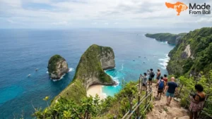
Mount Batur sits within a larger caldera that is among the most significant volcanic formations in Southeast Asia. The caldera stretches roughly 13 kilometres across at its widest point, and Lake Batur, visible from the summit and from the approach road, occupies the caldera floor. The scale of this landscape is not fully apparent until you are standing on the crater rim looking down.
Understanding the caldera matters for a practical reason: it explains why the weather behaves the way it does on the mountain. The caldera creates localised weather patterns. Cloud can sit in the caldera basin while the summit above it remains clear, or cloud can cap the summit while the caldera below is in sunshine. Reading weather conditions for this trek requires understanding that a forecast for Kintamani town does not reliably predict conditions at the crater rim. Your guide’s local knowledge of how cloud moves on a given morning is one of the genuinely useful things a good guide provides.
Cultural Significance in Balinese Tradition
Gunung Batur holds a specific place in Balinese Hindu cosmology. Balinese tradition regards the mountain as the abode of Dewi Danu, the goddess of lakes and rivers, and the crater lake is considered spiritually significant. Pura Ulun Danu Batur, one of Bali’s most important directional temples, was originally located at the crater rim before a 1926 eruption destroyed the original site. The temple was rebuilt at Penelokan, the village overlooking the caldera, where it remains an active site of worship.
This context does not change the physical experience of trekking the mountain, but it changes the way you see what you are walking through. The crater lake below is not simply a scenic feature. The mountain itself has a presence in the lives of the communities around it that goes beyond tourism. Trekkers who understand this tend to engage with the experience differently, and guides who carry this knowledge enrich the climb in ways that purely logistical guides cannot.
Is This Trek Right for You
The “suitable for beginners” label that appears on virtually every Mount Batur trek listing is not wrong, but it is incomplete in ways that lead people to arrive underprepared. The trek is manageable for someone without technical mountaineering experience. It is not manageable for someone without a reasonable baseline of physical fitness. Understanding the difference before you book saves a difficult experience on the mountain.
Honest Fitness Assessment for First-Timers
A useful self-assessment for this trek involves thinking honestly about the following questions. Can you walk continuously uphill for ninety minutes to two hours without stopping for extended rest? Are you comfortable walking on uneven, loose ground in the dark with only a headlamp for light? Can you tolerate cold temperatures in the range of 10 to 15 degrees Celsius without it significantly affecting your ability to function? If the answers are yes to all three, the trek is very likely within your reach.
The physical demands break down practically like this:
- The lower trail section is gradual and manageable for most fitness levels, taking roughly sixty to seventy minutes
- The upper section involves steeper gradient and loose volcanic soil underfoot, demanding more consistent effort and balance
- The final approach to the rim is the most demanding segment, typically taking thirty to forty-five minutes of focused climbing
- The descent, which many people underestimate, places sustained load on the knees and requires controlled footing on the same loose terrain
People who exercise two to three times per week at moderate intensity, including any activity that involves sustained walking or cardio, generally find the trek demanding but achievable. People who are largely sedentary in their daily lives will find the upper sections genuinely difficult and may need to move at a slower pace than the group.
Age, Health Conditions, and Who Should Reconsider
Age alone is not a reliable predictor of trekking suitability. Healthy and regularly active adults in their fifties and sixties complete the Mount Batur trek without difficulty. Younger adults who are not physically active may struggle more than older hikers who maintain fitness. The relevant variable is physical condition, not age.
Conditions that warrant genuine caution or medical consultation before this trek include:
- Heart or cardiovascular conditions, particularly those aggravated by sustained exertion
- Significant knee or hip issues, as both ascent and descent place load on these joints
- Respiratory conditions that are affected by cold air or exertion at altitude
- Pregnancy at any stage, given the exertion level, cold, and uneven terrain
- Recent surgery or injury to lower limbs that has not fully healed
If any of these apply, speaking with a doctor before booking is the right step. Informing your guide in advance of any relevant conditions is also worth doing, as a good guide adjusts the pace and rest frequency accordingly.
Solo Trekkers, Couples, and Small Groups
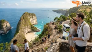
Solo trekkers are common on the Mount Batur trail and the experience works well independently. Most guides manage groups of two to six people, and solo travellers are typically paired with other solo trekkers or small groups at the time of booking. If you want a fully private experience, most operators offer private guide arrangements for a premium that is usually in the range of twenty to thirty percent above the shared rate.
Couples who want a shared physical experience with genuine emotional resonance consistently rate the Mount Batur sunrise among the most memorable things they do in Bali. The combination of the pre-dawn effort, the darkness, the summit arrival, and the sunrise creates conditions for a shared experience that most tourist activities simply cannot replicate.
Small groups of three to five people get a particularly good version of the trek because the guide can move at a coherent pace, stops are coordinated efficiently, and the summit feels less crowded than it does with larger parties. Groups above eight people begin to feel logistically slower, and the summit experience at peak season with multiple large groups present can feel significantly more populated than the solitary wilderness impression that photographs create.
The Full Trek Experience From Midnight to Morning
The arc of a Mount Batur sunrise trek begins well before the trail does. Understanding the full sequence from hotel departure to post-trek return helps you approach the day as a coherent whole rather than a series of disconnected logistics.
Leaving Your Hotel Before Sunrise
Most reputable operators schedule hotel pickup between 1:30am and 2:30am depending on your accommodation location and the distance to the trailhead. Pickup from central Ubud typically occurs around 2am. Pickup from south Bali areas like Seminyak or Canggu usually starts closer to 1:30am to account for the longer drive.
The drive to Toya Bungkah or the designated starting point takes between forty-five minutes and ninety minutes. Most people sleep or rest in the vehicle. Some find this impossible due to pre-trek nerves or simple unfamiliarity with sleeping in a moving car at 2am. Either is fine. What matters is that you have eaten something light before departure and have your headlamp charged and accessible before you get into the car.
Arriving at the Base and Meeting Your Guide
Arrival at the base area typically happens between 3am and 3:30am. There will be other groups assembling, headlamps moving in the dark, guides checking equipment, and a general atmosphere of purposeful early-morning activity. Operators usually have a small facility at the base where you can use a bathroom before the climb begins. Take this opportunity. There are no facilities on the trail.
Your guide will introduce themselves, check your footwear and headlamp, and confirm the group’s pace preference and any physical considerations they need to know about. This is the moment to mention knee issues, breathing conditions, or any other relevant health information if you have not already communicated it during booking. A good guide asks. A less attentive one may not, which is itself a useful piece of information about what to expect.
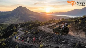
The Climb in Darkness
The early sections of the trail are easier than many people anticipate. The gradient is manageable, the path is reasonably defined, and the rhythm of walking in a line with headlamps illuminating the ground immediately ahead settles into something almost meditative. The darkness is a feature of this trek, not merely a condition to tolerate. It narrows your attention to the immediate: the next step, the sounds of the forest gradually giving way to the sounds of open volcanic terrain, the temperature dropping noticeably as you gain elevation.
The physical effort begins to accumulate from around the halfway point. The gradient increases and the terrain underfoot becomes looser. Rest stops are typically called by the guide at natural breaking points, but you can and should ask to stop if you need to. There is no shame in pacing carefully. Trekkers who push too hard on the lower sections to keep pace with faster group members often arrive at the upper section with diminished capacity for the harder terrain ahead.
The sounds change as you climb. The forest canopy thins and eventually disappears. Wind becomes more present. The headlamps of groups both ahead and behind you become visible as points of light on the mountain, which gives a useful sense of scale and progress.
Reaching the Crater Rim
Arrival at the crater rim typically occurs between 5am and 5:30am, timed to coincide with sunrise. The final approach involves the steepest and most technically demanding section of the trail, and many trekkers describe a combination of physical fatigue and heightened anticipation in these last thirty minutes. The rim itself appears suddenly: you step up over a ridge and the landscape ahead opens completely.
The crater rim is a broad ridge, rocky and uneven, with the caldera dropping away dramatically on the inner side and the hillside descending more gradually on the outer. The wind at the rim is usually stronger than anything you experienced on the climb, and the temperature here can be noticeably colder. This is the moment when the thermal layer you brought finally makes complete sense.
The Sunrise Moment and What It Really Looks Like
Sunrise at the Mount Batur crater rim on a clear morning is a genuinely arresting experience, and describing it in vague superlatives does not serve anyone well. The light builds from behind the eastern ridge, which on clear days means behind the silhouette of Mount Agung in the distance. The first visible light is a pale band just above the horizon, blue-grey rather than warm, which gradually deepens to gold and orange as the sun approaches.
The moment the sun clears the ridge, the entire caldera is illuminated simultaneously. Lake Batur below catches the light and shifts from dark to silver. The volcanic terrain of the crater rim takes on reddish-brown tones that were invisible in the darkness of the climb. On the clearest mornings in the dry season, the view extends south toward the coast and you can see the light catching the ocean far below.
On days when cloud sits at rim level, the experience is different but not without its own quality. Cloud at altitude has a texture and movement that is striking from within. Breaks in the cloud reveal the caldera below in brief and dramatic glimpses. The sunrise itself may be diffused through cloud rather than direct, which produces a softer, more uniform light that some people find more atmospheric than the clear-sky version. The honest assessment is that a partly cloudy sunrise at the Batur rim is still a better experience than most things you will do in Bali. A completely overcast summit with zero visibility is disappointing, and it does happen. This is the weather risk that all Mount Batur trekkers accept.
Time at the Summit and the Descent Back Down
Most groups spend between forty-five minutes and ninety minutes at the rim, depending on conditions and the operator’s schedule. This time is used for photography, breakfast if the guide has carried food, warming up with hot drinks, and simply standing in the landscape. Guides at established points near the rim often cook eggs directly over fumarole vents, which is a small and memorable detail that no booking page mentions.
The descent takes approximately ninety minutes to two hours and is, for many people, harder on the body than the ascent. Downhill movement on loose volcanic soil requires constant braking effort from the thigh and knee muscles, and the cumulative fatigue from the climb means those muscles are already working. Trekking poles, if you have brought them or if the operator supplies them, are considerably more useful on the descent than the ascent. The pace is typically faster going down, but controlled footing remains important throughout.
What the Summit Actually Looks and Feels Like
The photographs do justice to the view but almost nothing to the physical character of the summit environment. Standing on the Mount Batur crater rim is a sensory experience that extends well beyond what is visible in any image.
When the Sky Clears and When It Does Not
Clear summit conditions produce the experience that defines Mount Batur’s reputation. The panorama from the rim encompasses the full breadth of the Batur caldera, Lake Batur on the caldera floor, the outer caldera walls, the volcanic cone of Abang across the lake, and Mount Agung rising to the east. This view is genuinely one of the most complete volcanic landscape panoramas accessible by hiking in Bali, and it rewards time spent looking rather than only photographing.
When cloud is present at rim level, which is more common during the wet season and particularly between January and March, the experience shifts. Trekkers inside cloud at the summit can see perhaps twenty to fifty metres in any direction. The crater edge is visible but not the drop below it. The atmosphere is damp and cold. Breaking cloud conditions, where visibility changes over minutes, produce a dramatic and unpredictable experience. Full overcast with no breaks is the outcome that represents a genuinely missed visual opportunity, and it cannot be fully predicted even with good forecasting.
Fumaroles, Volcanic Soil, and the Physical Character of the Rim
The fumaroles near the crater rim are one of the distinctive physical features that most guides overlook. These are natural vents in the volcanic ground through which steam and gases release continuously. The steam is visible, and the smell, a faint sulphur characteristic of active volcanic vents, is detectable in the immediate vicinity. The ground around active fumarole areas is warm to the touch and the soil has a pale, bleached quality distinct from the darker volcanic aggregate elsewhere on the rim.
The overall surface of the rim is rough and uneven. Large blocks of lava, smaller volcanic aggregate, and sections of glassy solidified lava create a surface that requires attention underfoot even once you have stopped climbing. Walking along the rim to find a better viewpoint or photograph position requires the same care as the upper trail. The inner crater edge drops steeply and there are no barriers. Guides maintain group members at a safe distance from the edge, but awareness of your footing at all times is the correct posture throughout the summit visit.
How Long to Stay Up Top
The instinct for many trekkers is to photograph the sunrise and begin descending before the summit crowd builds. This is a reasonable approach during peak season months from July through September when the rim can feel genuinely populated by 6am. Outside peak season, particularly in the shoulder months of April, May, and October, the summit tends to be quieter and staying longer is more rewarding.
The post-sunrise light, from about thirty minutes after the sun clears the horizon, is excellent for photography and offers a different quality to the scene than the sunrise moment itself. The full landscape is illuminated without the high contrast of the rising sun, and details in the caldera and surrounding terrain become more visible. If your energy and your schedule allow it, staying at the rim until around 7am before beginning the descent gives you a more complete experience of the summit environment.
Guided or Self-Guided Trekking on Mount Batur
This is a question that comes up consistently, and the answer is more nuanced than most guides acknowledge. The Batur Trekking Guide Association, a local organisation that has historically asserted control over access to the trail, has created a situation where independent trekking has faced practical challenges. Understanding the current landscape around this question helps you make a genuinely informed decision.
Why Most Hikers Choose a Guide
Beyond the association question, a good guide adds real value to the Mount Batur experience in ways that experienced trekkers sometimes underestimate until they are on the mountain. The trail is not always clearly defined in the dark, particularly on the upper sections where the volcanic terrain lacks obvious path markings. A guide who has done the climb hundreds of times knows exactly where to place each step and how to navigate the route efficiently.
Weather reading is the other significant contribution. A local guide with deep familiarity with Batur’s conditions can assess the cloud pattern on the approach to the caldera and give you a realistic read on summit visibility before you have committed fully to the upper section. This is knowledge that no weather app can replicate, and it is the difference between a summit experience and a clouded-out disappointment.
Guides also handle the human elements: coordinating rest stops, managing the group’s pace, carrying emergency equipment, and knowing what to do if a trekker needs assistance partway up the mountain. These are not trivial contributions, especially in the dark at altitude.
Self-Guided Trekking and the Realistic Challenges
Self-guided trekking on Mount Batur is possible and some experienced trekkers choose it, accepting the practical complications. The main challenges are trail navigation in darkness on the upper sections, where without prior experience of the route the path becomes ambiguous, and the social dynamics of the trailhead where independent trekkers may encounter pressure from the local guide association to hire a guide.
For first-time trekkers, the combination of unfamiliar terrain, pre-dawn darkness, and navigational uncertainty makes a self-guided approach considerably more stressful than the guided alternative. The experience of the climb itself is better when you are not also managing navigation. For trekkers who have completed the route at least once before and are comfortable with the terrain, self-guided can be a reasonable choice.
How to Evaluate a Guide Before You Book
Guide quality varies enormously across Mount Batur operators, and the difference between a skilled, knowledgeable guide and a minimally engaged one shapes the entire experience. Evaluating a guide before committing is a skill worth developing.
Useful questions to ask before booking:
- How many times has this specific guide completed the Batur trek? Look for guides who do this regularly rather than occasionally
- What does the guide carry in terms of emergency equipment? A first-aid kit, additional warm layers, and emergency lighting should be baseline
- What is the guide’s policy if conditions at the summit are unsafe? A good guide has a clear answer
- What is the guide-to-trekker ratio? One guide for more than eight trekkers without a support guide at the rear is a quality signal worth noting
- Does the guide speak English to a level that allows genuine communication on the trail? This affects both safety and the quality of cultural and geological context provided
Operator responses to these questions tell you a great deal. Specific, confident answers indicate operational care. Vague or deflecting responses indicate that these details have not been thought through, which suggests the overall quality of the operation.
Behavioural signals at the trailhead are equally useful. A guide who checks your headlamp, asks about your physical condition, and explains the route before the first step is a guide who takes the responsibility seriously. A guide who hands you a waiver to sign and starts walking is a different kind of guide entirely.
What to Pack for a Pre-Dawn Volcano Hike
Packing for the Mount Batur trek is an area where the advice in most guides is superficially correct but practically insufficient. “Wear warm clothes and bring a torch” covers about thirty percent of what you need to think through.
Layering for Cold at Altitude
The temperature at the Mount Batur crater rim at 5am in the dry season typically ranges between 10 and 16 degrees Celsius. In the wet season it can feel colder due to wind and moisture. For travellers who have been spending their time in lowland Bali at temperatures between 28 and 35 degrees, this is a significant and surprising contrast. People who pack for the Bali beach climate and assume the trek will be merely “a bit cool” consistently describe feeling colder than expected.
A functional layering system for this trek works like this:
- Base layer: a moisture-wicking long-sleeve shirt that moves sweat away from the body during exertion. Cotton holds moisture and becomes cold when wet, making it a poor choice for the climbing sections
- Mid layer: a fleece or light insulating jacket that provides warmth without excessive bulk. This is the layer you will want at the summit
- Outer layer: a lightweight windproof shell or light rain jacket. Wind at the rim cuts through mid layers without it, and if cloud is present at the summit, moisture in the air penetrates fleece quickly
- Lower body: lightweight trekking trousers or sturdy athletic leggings. Shorts are workable on the lower trail but insufficient at the summit
- Extremities: gloves and a beanie or buff. Your hands will be cold at the rim even if the rest of you is adequately layered, and head covering makes a genuine difference to overall warmth perception
Headlamp, Footwear, and Gear That Actually Matters
Your headlamp is the single most important piece of equipment you bring, and it deserves more attention than the generic “bring a torch” advice suggests. A headlamp with a minimum output of 200 lumens illuminates the trail adequately and gives you peripheral vision of the terrain on either side. Headlamps below this output make the dark sections of the upper trail unnecessarily difficult to navigate confidently. Check that batteries are fresh the day before the trek, not the morning of departure when replacement may not be straightforward.
Footwear is the second critical variable. Closed-toe shoes with grip are the absolute minimum. Trail running shoes with a lugged sole handle the volcanic terrain well and are lighter than hiking boots, which matters over four to five hours of movement. Full hiking boots with ankle support are appropriate for trekkers who have weak ankles or who want maximum stability on the loose upper sections. Flat-soled shoes, sandals, and regular sneakers with smooth soles perform poorly on the loose volcanic aggregate and make the upper section both harder and riskier than it needs to be.
Additional items worth including in your pack:
- A small daypack (10 to 15 litres) to carry layers, water, and snacks without bulk
- At least 1.5 litres of water; more if you run warm or perspire heavily during exercise
- Snacks with quick energy: bananas, energy bars, or dried fruit for the upper sections
- A fully charged power bank if you are carrying a smartphone for photography
- Trekking poles if you have them; the descent specifically is easier with them
What to Eat and Drink Before and During the Trek
The 2am departure time creates an eating dilemma that most people navigate poorly. Eating a full meal at 1:30am before pickup feels deeply unnatural and is unnecessary. Eating nothing and trekking for four hours on an empty stomach is also a poor choice that contributes to fatigue and, in some cases, nausea.
The practical approach is to eat a moderate meal the evening before, finish eating by 9pm, sleep for a few hours, and then eat a small, easily digestible snack before or during the drive to the trailhead. A banana, some crackers, or a small portion of bread gives you something in your system without the heaviness of a full meal. Most operators include a breakfast at the summit or at a viewpoint after descent, so the post-trek meal is covered.
Hydration in the twenty-four hours before the trek is more important than most people realise. Arriving well hydrated means you need less water during the climb itself and your body regulates temperature and exertion more effectively. Alcohol the evening before the trek significantly impairs your capacity to handle exertion and cold the following morning, which is a choice you will notice acutely somewhere on the upper section.
Timing, Seasons, and Sunrise Visibility
Getting the timing right for a Mount Batur sunrise trek involves understanding both the annual seasonal pattern and the daily departure timing. Neither is complicated, but both affect the experience more than most people account for.
Best Months for Clear Summit Views
Bali’s dry season runs from approximately April through October, with May, June, and September typically offering the most reliable combination of clear skies and manageable humidity. July and August produce the highest frequency of clear summit mornings but also the highest tourist volumes, meaning the crater rim at dawn in these months feels noticeably more populated.
The months on either side of the peak dry season, specifically April, May, and September to early October, offer the best balance between clear weather and a less crowded summit. Visibility is high, sunrise timing is good, and the trail and summit area feel more spacious. For travellers who have flexibility in their Bali dates, scheduling the Mount Batur trek in these shoulder months is worth prioritising.
How Wet Season Changes the Experience
The wet season from November through March brings higher cloud frequency at altitude, increased chance of rain during the climb, and greater variability in summit visibility. This does not mean wet season trekking is a bad choice, but it requires adjusted expectations and a degree of flexibility.
Wet season mornings often begin with cloud sitting in the caldera basin while the summit above is clear, which produces a spectacular inversion effect where the trekker looks down onto a sea of cloud with the caldera landmarks invisible beneath it. This is a legitimately beautiful experience that dry season trekkers almost never see. Conversely, wet season can also produce complete overcast at the rim with minimal visibility, which is the outcome that represents the primary weather risk.
January and February are the months of highest rainfall and lowest summit visibility probability. Trekkers with fixed travel dates in these months should discuss current conditions directly with their operator before committing, as experienced local guides have a good read on the week-to-week weather pattern.
Departure Time and Crowd Patterns at the Summit
Sunrise time at Mount Batur varies across the year between approximately 5:45am in June and 6:30am in December. Most operators calibrate their departure times to arrive at the rim approximately thirty minutes before sunrise, which is the standard approach. The practical implication is that departure times shift seasonally, and if an operator quotes you a fixed 2am departure regardless of the month, it is worth checking whether this is genuinely calculated for the current sunrise time or simply a default.
The summit crowd pattern during peak season is worth understanding. The crater rim between 5am and 6am in July and August can have forty to sixty trekkers from multiple groups simultaneously. This is not dangerous, but it does change the character of the experience significantly. Trekkers who arrive earlier than the standard grouping, through earlier departure times, tend to have a quieter summit experience and occasionally catch pre-sunrise colours that the standard departure timing misses. Asking your operator about early departure options is a legitimate request.
Trek Packages, Pricing, and What Should Be Included
Price confusion around Mount Batur trek packages is common and stems from inconsistent inclusions across operators. Understanding what a complete package looks like makes it easier to compare quotes honestly.
Typical Price Ranges and Duration
Mount Batur trek packages as of 2025 and 2026 fall broadly into the following ranges:
| Package Type | Duration | Approx. Price per Person (USD) |
|---|---|---|
| Shared Group Trek | 5 to 6 hours total | $35 to $55 |
| Private Guide Trek | 5 to 6 hours total | $55 to $80 |
| Combined Trek Plus Breakfast | 6 to 7 hours total | $50 to $75 |
| Combined Trek Plus Hot Spring | 7 to 8 hours total | $65 to $100 |
Prices through international booking platforms typically sit fifteen to twenty-five percent above direct booking prices due to platform commission. The experience provided by the underlying operator is often identical regardless of booking channel; what changes is the price paid and the communication pathway for any questions or changes before the trek.
What a Well-Structured Package Covers
A complete Mount Batur trek package from a reputable operator should include: hotel pickup and drop-off, a certified local guide for the full duration, a headlamp if you do not have one, basic safety equipment carried by the guide, and a post-trek breakfast either at the summit or at a viewpoint restaurant on the way back. Entry fees to the trekking area, where applicable, should also be included.
Items that are legitimately priced separately include personal equipment like trekking poles, upgraded photography packages, private guide arrangements over the shared rate, and combination activity add-ons like hot spring visits or sunrise viewpoint stops on the return journey.
If a quoted package is significantly below the ranges above and the inclusion list is vague, the gaps are worth identifying explicitly before booking. The most common omission in underpriced packages is breakfast and hotel pickup, which are then added as extras that bring the total above the inclusive package price anyway.
Booking Direct Versus Booking Through Platforms
International platforms offer familiarity, consolidated reviews, and a payment interface many travellers trust. Direct booking with a Bali-based operator or travel provider offers better flexibility, more accurate information about current trail and weather conditions, and easier communication about specific requirements or preferences before the trek. For travellers with specific needs, direct communication before booking consistently produces a better-matched experience. For travellers who prioritise booking simplicity and do not have special requirements, platform booking is a perfectly functional approach.
Mistakes That Make the Trek Harder Than It Needs to Be
Every trek guide should include this section, and almost none do. The errors that make Mount Batur harder are predictable, preventable, and consistently made by people who did not know to avoid them.
Packing inadequate warmth is the most common mistake. Travellers in Bali for beach and cultural tourism have typically not brought warm layers because lowland Bali does not require them. The assumption that a light hoodie will cover the summit cold leads to genuine discomfort at the rim and a shortened summit visit to escape the temperature. If you have not brought appropriate layers from home, purchasing a basic fleece in Ubud before the trek is a worthwhile twenty-dollar investment.
Wearing the wrong footwear is the second most prevalent error. The volcanic terrain on the upper sections of the trail makes grip a functional safety consideration, not an aesthetic one. Trekkers in sandals or flat-soled shoes move more slowly, expend more energy maintaining balance, and face a meaningfully less secure descent. If your accommodation or a nearby sports shop can loan or rent trail shoes, use that option.
Eating and drinking poorly in the twenty-four hours before the trek affects performance on the mountain in ways that feel disproportionate to the oversight. A heavy meal the night before combined with dehydration and a hangover produces a genuinely unpleasant trekking experience. These are entirely within your control.
Arriving at the trailhead without a charged headlamp is less common but happens and is completely avoidable. Check the charge the evening before. Carry spare batteries if the headlamp uses them rather than a built-in rechargeable battery.
Underestimating the descent is the final consistent mistake. Most first-time trekkers are mentally prepared for the physical effort of climbing and are surprised by how demanding the descent is on the knees and thighs. Descending loose volcanic soil requires sustained muscular braking. Trekking poles help significantly. Moving at a deliberately controlled pace rather than rushing the descent protects the joints and reduces the risk of slipping on the loose upper sections.
After the Trek
The post-trek portion of the day is something no booking description covers, and it matters more than it sounds. Understanding what the next few hours typically look like helps you plan the rest of your Bali day intelligently.
Most operators schedule a breakfast stop after the descent and return from the mountain. This is typically at a restaurant on the rim road above Kintamani with a caldera view, and arriving there with an appetite after four to five hours of activity makes the meal genuinely satisfying. Nasi goreng, eggs, toast, and fresh fruit are standard offerings, and the view from these establishments in the morning light is a fitting close to the summit experience.
The drive back to your accommodation from the trailhead takes the same time as the outward journey: forty-five minutes to ninety minutes depending on your base location. Most trekkers sleep during this return journey without difficulty. Arrival back at your hotel or villa typically occurs between 9am and 11am depending on the operation.
Physically, the rest of the day tends to feel slow. The combination of disrupted sleep, early activity, and the muscular effort of the descent means that most people who attempt ambitious afternoon plans after a Mount Batur sunrise trek do not follow through on them. Building a rest afternoon into your schedule on trek days is not laziness. It is sensible planning that leaves you in good condition for whatever comes next in your Bali itinerary.
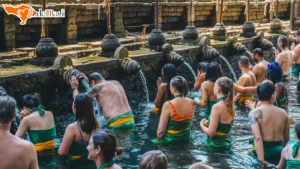
The natural activity pairing for a Mount Batur trek day, if you want something gentle in the afternoon, is a visit to one of the hot spring facilities near Lake Batur. The Toya Devasya springs sit directly on the caldera lake and offer a genuinely restorative soak after a morning of volcanic trekking. The contrast of the active physical morning and the still, warm afternoon is one of the more satisfying combinations available on a single day in Bali.
Getting the Most Out of a Mount Batur Sunrise Trek
The difference between a good Mount Batur experience and a memorable one rarely comes down to the mountain itself. The mountain delivers consistently for people who approach it with good preparation and realistic expectations. What it cannot compensate for is poor planning, inadequate gear, or an operator whose standards fall below what the experience deserves.
Book with enough advance notice to secure a morning that aligns with a favourable weather window. Check the forecast three days out, then again the day before. If your operator does not proactively communicate current trail and weather conditions in the forty-eight hours before your trek, that silence tells you something about their level of care.
Arrive at the base mentally prepared for the actual physical experience rather than the idealised version. The darkness, the cold, the loose terrain, and the sustained effort of the upper section are all real. They are also all manageable, and working through them is what makes the summit arrival and the sunrise meaningful rather than simply scenic.
Stay at the rim long enough to let the landscape settle into your memory. The temptation to photograph constantly is understandable, and photographs are worth taking. But the Mount Batur crater rim at dawn is also the kind of place worth standing in for a while without a screen in front of your face. The view is best experienced directly, in the cold morning air, with the caldera below and the day beginning over the eastern ridge.
That is the version of the experience that stays with people long after the photographs have been sorted and forgotten.