Most people planning a trip to Bali already know about the Mount Batur sunrise hike. They’ve seen the photos, read the itineraries, and noted the 3am departure. What they don’t always realize is how different the experience of hiking in Bali can be depending on which trail they choose, when they go, where they’re staying, and what they actually want from a morning outdoors.
Bali isn’t a single hiking destination. It’s a collection of very different landscapes sitting within a relatively small island: active volcanic terrain in the north, dense rainforest in the highlands, cascading waterfalls hidden in the interior, and rice field paths winding through villages that have barely changed in decades. The trails that connect these landscapes serve completely different purposes for completely different travelers.
The problem most visitors run into isn’t a lack of options. It’s that every article about Bali hiking lists the same trails with the same descriptions, and none of them help you actually decide. After reading five of them, you still don’t know which trail fits a four-day trip, whether you need a guide, how early you need to wake up if you’re staying in Seminyak, or what “moderate difficulty” actually means for someone whose regular exercise is a thirty-minute walk.
This guide is built to close that gap. Every trail entry covers what the experience genuinely feels like, who it suits, what the logistics look like from different parts of Bali, and what you should know before you commit to a booking.
Why the Trail You Choose Changes the Entire Day, Not Just the View
There’s a tendency to treat all Bali hikes as interchangeable bucket-list items. You pick one, you do it, you post the photo. But the choice of trail has a much larger effect on your day than most people anticipate, and it’s not just about scenery.
A Mount Batur sunrise hike means waking before midnight if you’re based in Seminyak. It means sharing the summit with several hundred other hikers at dawn. It means reaching the top tired, then facing a two-hour drive back before the rest of your group has had breakfast. That’s not a complaint about the experience. For many travelers, it’s genuinely one of the most memorable mornings of their lives. But it’s a full-day commitment disguised as a morning activity, and going in without understanding that often leads to the post-hike regret travelers express when they’re too exhausted to do anything else.
A Campuhan Ridge Walk in Ubud, by contrast, starts five minutes from the center of town. It takes less than two hours at a comfortable pace. You can be back at a warung with a coffee before 8am, with the rest of the day completely open. The experience feels nothing like Batur, but for some trips and some travelers, it fits far better.
The point isn’t that one is better than the other. It’s that the decision should come before the booking, not after.
Matching the Hike to Your Trip Style Before You Book Anything
The most useful way to approach Bali hiking is to start with what your day can actually hold, not with which trail sounds most impressive. A few honest questions tend to cut through the noise quickly.
How many days are you in Bali, and what else is planned around the hike? If your trip is four days long and includes Ubud, Uluwatu, and a day trip to Nusa Penida, a 3am departure for Batur will genuinely affect the day that follows it. If you have ten days and flexibility, that’s a different calculation entirely.
What does your group look like? A couple in their thirties who hike occasionally at home will find Mount Batur manageable and rewarding. A family with children under twelve will find Campuhan Ridge or Jatiluwih far more enjoyable and safer. A solo traveler wanting something quieter than Batur but more challenging than a rice field stroll will find Mount Abang or the Munduk twin lakes trail much closer to what they’re looking for.
What time of year are you visiting? Bali’s dry season runs roughly from April through October. During this window, most trails are in good condition, summit views are clearer, and the approach paths are easier underfoot. The rainy season doesn’t eliminate hiking in Bali, but it changes which trails are enjoyable and which become genuinely difficult. More on that later in this guide.
How Fitness, Time, and Travel Group Shape the Right Decision
The table below gives a quick reference for matching trail type to traveler situation. This isn’t a ranking of which hikes are better. It’s a planning tool to help you choose without guesswork.
| Trail | Fitness Required | Total Time Commitment | Best For |
|---|---|---|---|
| Mount Batur | Moderate | Full morning (5 to 7 hours including travel) | Adventurous travelers, couples, small groups |
| Mount Agung | High | Full day or overnight | Experienced hikers only |
| Campuhan Ridge Walk | Low | 2 to 3 hours | Couples, solo travelers, families, casual walkers |
| Sekumpul Waterfall Trek | Moderate | Full day from south Bali | Nature and photography travelers |
| Munduk Twin Lakes | Moderate | Half day to full day | Travelers wanting solitude and forest scenery |
| Jatiluwih Rice Terraces | Low to moderate | 2 to 4 hours | Families, cultural travelers, first-timers |
| Mount Abang | Moderate | Half to full day | Travelers seeking volcanic terrain without Batur crowds |
| Banyumala Twin Waterfalls | Low to moderate | Half day | Couples, solo travelers, photography enthusiasts |
Mount Batur Still Earns Its Reputation, but Only If You Plan It Right
Mount Batur sits at 1,717 meters above sea level in the Kintamani region of northeast Bali. It’s an active volcano, which means the landscape at the summit is unlike anything else on the island: dark volcanic rock, sulfuric steam rising from vents, and on a clear morning, a sunrise that spills orange light across Lake Batur below and the silhouette of Mount Agung in the east. The reputation is earned.
The issue isn’t the hike itself. The issue is that most travelers arrive underprepared for the logistics and mildly surprised by the crowd. Both of those things are solvable with a little advance knowledge.
What the Pre-Dawn Departure Actually Means for Where You’re Staying
Here is the detail that most trail guides skip. When they say “depart at 3am,” they mean depart from the trailhead. The trailhead is near Toya Bungkah village at the base of the mountain, which takes approximately one hour by car from Ubud, two hours from Seminyak or Canggu, and closer to two and a half hours from Uluwatu.
Working backwards: if you’re based in Ubud and your guide picks you up at 2am, you’re setting an alarm for 1:30am. If you’re based in Seminyak, that pickup is at 1am. Many travelers staying in the south of Bali don’t realize that the night before a Batur hike is functionally lost, and the day after it is slow. Building this into your trip planning makes the experience much easier to enjoy without feeling wrecked afterward.
If you’re based in or near Ubud, the Batur hike integrates cleanly into the trip. If you’re in the south, consider whether it’s worth moving accommodation for one night to somewhere in the Kintamani or Ubud area, or factor in the full impact on the surrounding days.
At the Summit, the Crowd Is Real and the Timing Matters More Than You’d Think
Mount Batur is one of the most popular hikes in Southeast Asia. On a clear morning during peak season, you may share the summit with three hundred or more hikers. The path up is a procession after a certain point, and the best crater views require knowing where to position yourself.
This is one of the more practical reasons to hike with a local guide beyond the commonly cited safety argument. Guides who do this trail regularly know which side of the crater catches the cleanest sunrise light, when to push ahead to avoid the slowest section of the crowd, and where to sit quietly away from the main cluster of hikers while the sky shifts color. That operational knowledge is worth more than the navigation assistance alone.
The summit also has small warungs selling coffee and snacks, and boiled eggs cooked using volcanic steam directly from the ground. It’s a small but genuinely surprising moment that most visitors mention after the fact as one of their clearest memories from the morning.
Why Some Travelers Come Back Saying It Was Their Best Day, and Others Don’t
The difference between loving the Batur hike and feeling ambivalent about it usually comes down to expectation management. Travelers who understand what they’re signing up for, arrive rested, choose a guide with good reviews, and go during the dry season for clearer summit conditions almost always describe it as a highlight.
Travelers who underestimated the early departure, arrived exhausted, faced clouded views, or booked an unverified guide through a guesthouse notice board tend to feel they got the Instagram version of an experience rather than the real one. The hike itself hasn’t changed. The preparation made all the difference.
Campuhan Ridge Walk Is Not Just for Casual Walkers
Campuhan Ridge Walk in Ubud gets categorized as the easy option, which is accurate in terms of physical demand. It’s a gentle, mostly flat ridge path of about nine kilometers that winds through low jungle grass, coconut palms, and open valley views above two converging rivers. No steep climbs, no pre-dawn alarms, no guide required.
What gets undersold is how genuinely pleasant the trail is when you walk it at the right time, and how unpleasant it can become when you don’t. The difference between a peaceful, photogenic walk and a crowded, hot march through other tourists’ selfie sessions comes down to a window of about two hours in the morning.
Why the First Hour of the Morning Completely Changes This Trail
The trail is at its best between 6am and 8am. The light is soft, the temperature is cool enough to enjoy walking, and the path is quiet enough that you can actually hear the birds and the sound of the rivers below. Local Balinese use the early section of the trail for their own morning walks, which gives the first stretch a neighborhood feel that’s completely different from the tourist-heavy atmosphere that settles in later.
By 9am, the light has shifted to a harsher midday quality, the temperature starts to climb, and visitor numbers increase noticeably. By 10am, it’s a different experience. Not a bad one, but clearly not the same walk. If you’re staying in Ubud and your hotel is within twenty minutes of the trailhead, this is one of the most accessible hikes you’ll find anywhere in Bali. Set an early alarm and you won’t regret it.
What Locals and Photographers Know About the Best Section of the Path
The trail begins near Pura Gunung Lebah temple, crosses a small bridge, and rises onto the open ridge. The middle section, roughly between the 1km and 4km marks, offers the most open views across both river valleys and is where the quality of light in the early morning is most dramatic. Photography travelers who plan specifically around this trail tend to set up here with the sun still low, then walk the rest at a comfortable pace.
The trail eventually passes through small Subak irrigation channels and patches of working rice fields before turning back toward Ubud’s main streets. Finishing with a slow breakfast at one of the cafes overlooking the ridge from above is a natural endpoint that most regular visitors to Ubud treat as part of the experience, not an afterthought.
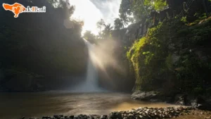
Sekumpul Waterfall Trek Rewards Patience More Than Fitness
Sekumpul is located in North Bali, roughly two hours from Ubud and three to three and a half hours from the Seminyak or Canggu area. It’s a cluster of several waterfalls dropping into a jungle basin, generally considered among the most beautiful natural sites on the island. The physical demand of the trek itself is moderate: there are steep stairs descending into the gorge, river crossings, and uneven terrain underfoot.
What makes Sekumpul genuinely different from most Bali hikes is how the experience builds. Unlike a mountain summit where the payoff is at the top, Sekumpul reveals itself progressively. You hear the falls before you see them. You cross a river to access the base. You move between multiple falls rather than standing at one fixed viewpoint. For travelers who appreciate immersion over achievement, this trail consistently delivers something different.
The Trek In Is Longer Than Most Expect, and That’s Part of the Experience
Most visitor accounts underestimate the total time at the site. The descent into the gorge and the walk between the different waterfall sections takes between one and a half and three hours depending on pace and how much time you spend at each point. Add the return climb out and the experience is comfortably a half-day activity at the site alone.
The terrain after rainfall is slippery in sections, which is worth knowing in advance. Good grip footwear makes a noticeable difference. Sandals are not practical here. The stairs leading into the gorge are the steepest section, and while they’re not technically demanding, they require a reasonable level of confidence on uneven steps.
The majority of visitors hire a local guide at the entrance, which is genuinely worthwhile. Guides navigate the river crossings, know which viewpoints to prioritize, and manage the timing between the different falls more efficiently than self-guided exploration allows.
North Bali Distance from the South Makes This a Dedicated Day Trip
For travelers based in Seminyak, Canggu, or Uluwatu, visiting Sekumpul means committing most of the day to driving and the trek itself. The road into North Bali passes through the highlands and the scenery along the way is part of the experience, but the total time investment is significant.
A common approach for travelers making this trip is to combine Sekumpul with other North Bali stops: the Munduk area, Lake Tamblingan, or the coastal temples near Singaraja. This turns what could feel like an exhausting single-destination round trip into a full-day northern Bali exploration that makes the drive worthwhile. If your itinerary has a day allocated for “North Bali,” building Sekumpul into the center of it is a logical and rewarding structure.
Mount Agung Is a Different Category of Hike Entirely
Mount Agung stands at 3,142 meters, making it the highest peak in Bali and one of the most sacred mountains in Balinese Hinduism. It is the spiritual axis of the island. Balinese temples are traditionally oriented toward it, and it carries a religious significance that shapes how the hike is approached and regulated.
It is also a genuinely demanding physical undertaking. The ascent involves nine to twelve hours of continuous hiking depending on the route, significant elevation gain through dense vegetation, and rocky exposed terrain near the summit. Weather conditions at that altitude are unpredictable and can deteriorate quickly.
Who Should Consider It and Who Should Honestly Choose Something Else
Mount Agung is suitable for travelers who hike regularly, are comfortable with sustained physical effort over many hours, and are visiting during the dry season when the trail is stable. The summit offers views across eastern Bali, the Lombok strait, and on very clear mornings, the peak of Rinjani across the water. For hikers who’ve done similar terrain elsewhere, the reward matches the effort.
For travelers who don’t hike regularly, who have knee or joint considerations, who are visiting during the shoulder season, or who have a packed itinerary around the hike, Agung is likely to be more difficult than it’s worth. Mount Batur offers a comparable volcanic experience at a fraction of the physical demand and is a genuinely excellent substitute for most travelers who are drawn to the idea of Agung but uncertain about their fitness level.
The honest recommendation: if you’ve researched Agung and find yourself wondering whether you can manage it, the answer is probably not without serious preparation. That’s not discouragement. It’s the kind of information that prevents a dangerous situation mid-mountain.
Why Experienced Hikers Still Hire Guides for This One
Even for seasoned hikers, a certified guide for Mount Agung is not optional in any practical sense. The trail is poorly marked in sections and conditions change rapidly with altitude. Guides also carry the cultural knowledge necessary for navigating a mountain that is actively sacred to the Balinese people. Certain behaviors, dress considerations, and summit conduct are expected, and a guide manages that dimension of the experience alongside the physical navigation.
The two main routes, the Besakih route from the south and the Pasar Agung route from the southeast, serve different purposes. Besakih reaches the true summit but is a longer and more demanding day. Pasar Agung reaches a lower crater rim but is a more manageable hike for travelers attempting Agung for the first time. Your guide will recommend the appropriate route based on your fitness level and the time available.
Lesser-Known Trails That Solve the Crowd Problem
One of the most frequent complaints from experienced Bali travelers is that the popular hikes have become crowded in a way that changes the character of the experience. Mount Batur at sunrise during peak season is spectacular, but it is also genuinely busy. If what you’re looking for is a sense of being in nature rather than a shared spectacle, there are several trails that serve that purpose well without requiring you to compromise on scenery or experience.
Mount Abang Offers Volcanic Terrain Without the Batur Crowds
Mount Abang sits on the eastern rim of the Batur caldera at 2,153 meters, higher than Batur itself and offering a wider caldera view that many hikers actually prefer once they’ve done both. The trail passes through dense forest rather than the exposed volcanic terrain of Batur, which means the approach has a completely different atmosphere. You’re walking through jungle, not scrambling over ash and rock.
The number of visitors on any given morning is a fraction of what Batur receives. On quieter days, you may not see another hiking group at all. The summit view across the entire Batur lake and caldera is arguably more expansive than the view from Batur’s peak because you’re looking down from a greater height and a wider angle. For travelers who have already done Batur on a previous trip, or those who simply want the volcanic landscape without the crowd, Abang is the version of that experience most travel guides don’t mention.
Munduk Twin Lakes for Travelers Who Want Forest, Not Summit
The Munduk twin lakes trail connects Lake Tamblingan and Lake Buyan through a stretch of highland rainforest at around 1,200 meters elevation. The route is approximately eight kilometers one way, which most walkers complete in four to five hours depending on pace. It’s a trail for travelers who want sustained immersion in a green, quiet landscape rather than an ascent toward a dramatic viewpoint.
The trail passes through sections of ancient forest with significant biodiversity, small temple structures partly reclaimed by vegetation, and stretches of lakeside path where the only sounds are birds and water. The overall elevation change is gradual, making it accessible to travelers with moderate fitness without being so easy that it loses its character.
Munduk village itself is worth combining into the day. The area is cooler than coastal Bali by several degrees, and the highland landscape around the village has a calm that feels genuinely removed from the island’s more visited areas.
Banyumala Twin Waterfalls for a Short Trek with a Dramatic Payoff
Located in the interior of North Bali near Gobleg village, Banyumala is a shorter hike with a disproportionately striking endpoint. The trail descends through bamboo groves and along rocky riverbanks to reach twin waterfalls falling into a clear pool where swimming is possible. Total trekking time is roughly forty-five minutes to an hour each way.
For travelers who want a waterfall experience without the full-day commitment of Sekumpul, Banyumala sits well. It combines naturally with a Munduk day trip, as both are in the highland interior of North Bali and are close enough to visit in sequence without feeling rushed. Visiting early also means arriving before tour groups from the south reach the site, which at a destination this size makes a meaningful difference to the atmosphere.
Jatiluwih Rice Terraces as a Walk, Not Just a Viewpoint
Most visitors to Jatiluwih encounter it from a viewpoint or a restaurant terrace: an expansive sweep of stepped rice fields climbing the foothills of Mount Batukaru, listed as a UNESCO Cultural Landscape and recognized as one of the finest examples of the Subak irrigation system that has sustained Balinese agriculture for centuries.
What fewer travelers realize is that Jatiluwih has a network of walking paths that pass directly through the terraces rather than above them. Walking inside the fields is a different experience from observing them from a platform. The scale shifts. You move past individual paddies, see the irrigation channels up close, and walk alongside farmers working the land in the same way their ancestors did. The UNESCO designation isn’t ceremonial: the Subak system is still functioning and actively maintained.
The Difference Between Walking the Fields and Photographing Them from the Road
The viewpoint approach and the walking approach aren’t competing options. They’re two parts of the same visit. Arriving at Jatiluwih and spending the first twenty minutes at a higher point to understand the scale of the landscape, then descending into the trail that winds through the lower terraces, gives you both the panoramic perspective and the immersive one.
The walking paths range from easy flat sections along the widest terraces to narrower, slightly uneven paths between paddies that require a bit more attention underfoot. The total distance you walk depends on how far you take the trail, with a comfortable loop running between two and four kilometers for most visitors.
Early Entry Changes What This Place Feels Like
Jatiluwih receives an entrance fee for foreign visitors of around IDR 50,000 per person, which is low by any standard for a site of this quality. Arriving before 9am puts you in the terraces before tour buses arrive from the south. The light during that window is at its most useful for photography, but more importantly the atmosphere is quieter. Farmers start work early, and the presence of actual agricultural activity happening around you gives the visit a grounding sense of reality that disappears once larger groups arrive and the site shifts toward photo stop rather than living landscape.
Rainy Season Does Not Rule Out Hiking in Bali Entirely
The standard advice for Bali hiking is “go during the dry season,” which runs from approximately April through October. That’s accurate for most mountain hikes and genuinely important for safety on more demanding trails. But stating it as a blanket rule creates a misleading impression for travelers visiting between November and March.
Rainy season in Bali doesn’t mean continuous rain. It means afternoon and evening rain showers are common, mornings are often clear, and some areas of the island receive significantly more precipitation than others. The highlands and volcanic peaks are more affected than coastal areas. Within that context, the trail-by-trail picture is more nuanced than a single seasonal warning suggests.
Which Trails Stay Viable and Which Become Genuinely Risky
The trails that should be avoided or approached with serious caution during the rainy season are the volcanic summit hikes. Mount Agung becomes genuinely dangerous: the approach path is muddy, the upper slopes can be slippery on rock, and summit visibility is often entirely blocked by cloud. The experience is difficult to justify when conditions are that unreliable.
Mount Batur is more forgiving than Agung in wet season but still suffers from frequent cloud cover that obscures the sunrise, which is the primary reason most people make the climb. The hike can still be done, but the payoff becomes uncertain. Checking weather forecasts and discussing conditions with a local guide before committing is essential.
The trails that hold up well or actively improve during wet season form a different category:
- Campuhan Ridge Walk remains walkable in most conditions. Morning rain is less common than afternoon showers, and the vegetation along the ridge is at its deepest green during wet season.
- Sekumpul Waterfall is more dramatic with additional rainfall feeding the falls. The volume of water increases significantly, and the visual impact at the base of the falls is more powerful than during the dry season.
- Banyumala and other waterfall treks in the north also benefit from seasonal rainfall, with flow levels at their highest between December and February.
- Jatiluwih works well in the morning hours even during wet season, particularly because the rice fields are often more visually alive during growing periods that overlap with rainfall months.
How Waterfalls and Forest Trails Actually Benefit from Rainfall
There’s a common misconception that wet season hiking is inherently inferior. For summit chasers, that’s true. For travelers drawn to Bali’s jungle and waterfall landscape, wet season is actually when those environments are at their most vibrant. The forest is fuller, water features are more dramatic, and the reduced tourist volume means the experience is quieter.
The practical consideration for wet season hiking on these trails is footwear grip and awareness of flash flood risk near river crossings, which local guides manage well. If you’re visiting Bali outside the dry season and want to hike, the question isn’t whether to hike at all. It’s which category of trail you should be choosing.
Guided or Self-Guided Depends on the Trail, Not Just Preference
The guide question comes up constantly in Bali hiking planning, often framed as a preference issue: some travelers want the independence of going alone, others prefer the support of a guide. But the more useful way to think about it is trail-by-trail, because the answer genuinely varies.
Some trails in Bali require guides for safety or cultural reasons. Others are perfectly navigable independently with reasonable preparation. Treating the guide question as one-size-fits-all leads to either unnecessary expense or genuinely poor decision-making.
What a Local Guide Actually Provides Beyond Navigation
For the trails where guides are genuinely valuable, the value isn’t primarily navigation. On Mount Batur, the path to the summit is straightforward enough that physically losing your way is unlikely. What a guide provides is something different.
They carry knowledge of the mountain that changes the experience in concrete ways: which crater viewpoint catches the light first, when to leave the summit to avoid the worst of the crowd returning down the path, what the steam vents near the top mean and why they’re safe to approach, and how to time the descent for the best views of the lake rather than the back of someone else’s jacket. On Mount Agung and West Bali National Park hikes, navigation genuinely matters and guides are essential for safety reasons.
On a cultural level, guides at temple-connected trails like Lempuyang provide context for what you’re seeing that changes the visit from a scenic walk into something that actually makes sense. The 1,700 steps to the upper temple complex at Lempuyang are meaningful in a specific religious context that a guide can explain without turning the walk into a lecture.
For trails with wildlife sightings, like the Gunung Klatakan trail inside West Bali National Park, the guide relationship is required and the information is genuinely irreplaceable. Spotting a Bali Starling, one of the rarest birds in the world, requires a guide who knows the habitat patterns and timing. You won’t find that information online.
Trails Where Independent Hiking Makes Good Sense
Campuhan Ridge Walk, Jatiluwih, and the lower sections of Banyumala are all navigable without a guide for most travelers. The paths are marked, the terrain is manageable, and the risk is low. Bringing a downloaded offline map and starting early in the day covers the practical preparation needed.
For these trails, independent hiking gives you control over pace and timing that a group or guided walk doesn’t. You can stop for fifteen minutes at the spot where the light hits the rice field walls in a particular way, or sit quietly above the Campuhan river valley without worrying about keeping up with a schedule. That kind of slow, self-directed walking suits some travelers far better than a structured guided format.
Practical Things That Affect the Experience Before You Reach the Trailhead
The gap between a good hike and a frustrating one often has nothing to do with the trail itself. It has to do with preparation decisions made the day before: what time you set the alarm, what you put in your bag, whether you’ve confirmed transportation, and whether your body is ready to do what you’re asking of it. These practical details are unglamorous but they matter consistently.
Transportation Time from Different Parts of Bali to Each Trail Area
Transportation in Bali is overwhelmingly by private car or scooter. Public transport between major areas is limited and impractical for early morning trailhead arrivals. The times below reflect average private car journeys under normal traffic conditions, which during peak hours in South Bali can increase significantly.
| Trail / Area | From Seminyak/Canggu | From Ubud | From Uluwatu |
|---|---|---|---|
| Mount Batur (Toya Bungkah trailhead) | 2 to 2.5 hours | 1 to 1.5 hours | 2.5 to 3 hours |
| Mount Agung (Pasar Agung gate) | 2.5 to 3 hours | 1.5 to 2 hours | 3 to 3.5 hours |
| Campuhan Ridge Walk (Ubud center) | 1 to 1.5 hours | Walking distance or 5 minutes by car | 1.5 to 2 hours |
| Sekumpul Waterfall | 3 to 3.5 hours | 2 to 2.5 hours | 3.5 to 4 hours |
| Munduk / Twin Lakes | 2.5 to 3 hours | 2 hours | 3 to 3.5 hours |
| Jatiluwih Rice Terraces | 1.5 to 2 hours | 1.5 hours | 2 to 2.5 hours |
| Banyumala Twin Waterfalls | 2.5 to 3 hours | 2 hours | 3 to 3.5 hours |
For guided hikes, transportation from your accommodation to the trailhead is usually included in the package. Confirm this at the time of booking, along with the exact pickup time, not just the departure time from the trailhead.
What to Pack Changes Depending on Whether the Trail Is Volcanic, Jungle, or Rice Field
There is no single packing list that works across all Bali hikes. The differences between a pre-dawn volcanic climb and a morning rice field walk are significant enough that preparing identically for both leads to either overpacking or being genuinely underprepared.
For volcanic summit hikes, including Batur and Agung:
- Headlamp with fresh batteries (most of the ascent happens in complete darkness)
- Warm layer or light jacket (temperatures at altitude drop significantly before dawn)
- Sturdy closed-toe shoes with grip (volcanic sand and rock require solid footwear)
- Water of at least 1.5 liters per person
- Snacks with carbohydrates for sustained energy
- Thin gloves if you feel the cold easily
For jungle and waterfall trails, including Sekumpul, Munduk, and Banyumala:
- Waterproof footwear or trail shoes with grip (wet rock and riverbanks require traction)
- Light rain jacket or poncho (afternoon rain is possible, morning mist is common)
- Change of dry socks in a waterproof bag
- Insect repellent
- Sunscreen for the walk back out when cloud cover lifts
- More water than you think you need (humidity in jungle environments increases sweating even without direct sun)
For easy walks including Campuhan Ridge and Jatiluwih:
- Comfortable walking shoes (running shoes are entirely adequate)
- Sun protection including hat and sunscreen
- Light clothing that covers shoulders and knees if temple sections are on the route
- Water
When to Book and What to Confirm in Advance
For popular hikes during peak season, particularly Mount Batur between June and September, booking a guide two to three days in advance is sensible. The better-reviewed local guide operators fill up, and last-minute arrangements often mean accepting whoever is available rather than who is reliable.
When confirming a booking, clarify the following:
- Pickup time and pickup location (not just trailhead departure time)
- What is included in the fee: guide, transportation, entrance fees, breakfast or snacks at the summit
- Group size if you’re joining a shared group hike versus a private arrangement
- Cancellation or weather postponement policy
For self-guided trails, no advance booking is needed, but checking entrance gate opening hours is worthwhile. Jatiluwih typically opens from around 7am. Campuhan Ridge is accessible at any time. Sekumpul involves a local guide at the entrance who can usually be arranged on arrival, though arriving early ensures availability.
Choosing the Right Bali Hike Comes Down to Knowing What the Day Looks Like End to End
The most useful shift in thinking about Bali hiking is to plan the full day rather than just the trail. A mountain summit hike is also a 1am alarm, a two-hour drive in the dark, a descent that takes longer than expected, and a long journey back to your accommodation before noon. A rice field walk is also a slow morning coffee, a walk through a working village, and a return to town with the rest of the day intact. Both of those can be wonderful. Understanding which one fits your trip before you book is what makes the difference.
Bali’s hiking trails cover more variety than the standard articles suggest. There are genuinely quiet alternatives to the most photographed peaks. There are waterfall treks that improve with rainfall rather than suffering from it. There are short morning walks that require no planning beyond setting an early alarm, and there are multi-hour ascents that require a full night of rest, proper footwear, and a guide who knows the mountain.
The trails listed in this guide represent a range wide enough to serve almost any traveler and any type of trip. The decision framework across the sections here is designed to help you narrow that range to the trail that actually fits your situation, not just the one that looks best in photos.
If you’re looking for local guidance on planning a Bali hike as part of a broader itinerary, or want a trusted provider to handle the guide booking and logistics for you, Made From Bali Tour and Travel works with experienced local guides across these trails and can help you find the right fit for your schedule and travel style.